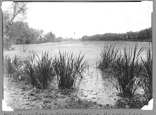
I have to admit that I'm a little confused about the layout of the east side of Sugar Land, particularly the area south of Highway-90A where Alkire Lake & Venetian Estates are located. I have other aerial photos that, I hope, will clear up some of my questions.
These 1st two photos come from the Rozelle family archive. T.C. labeled them as photos of Alkire (or Alligator) Lake. I presume they were taken at the point where Alkire Lake arcs closest to Highway-90A -- maybe 300 yards east of the Highway's intersection with Eldridge Road/Lombardy Street. Or, this may be at the same intersection -- just a few yards east of Lombardy as it enters Venetian Estates.
I don't have a date for this next photo which was taken from the top of the Char House looking southeastward toward what would become Venetian Estates. Judging from the cars & trucks, the photo dates from the late '40s. The Texas Highway Department laid the eastbound lanes of Highway-90A in 1947. Prior to '47 the Highway was just 2 lanes -- those next to the railroad tracks.
I think these next two photos were taken in the late '50s. They are a little repetitious, but they show the area at different times of the year -- when there was water in the low-lying gullies & when they were dry. Notice the hay barn/implement shed in the upper-right quarter of the picture (next to the railroad tracks toward Galveston).
This next aerial was shows Venetian Estates at the end of the '50s. It looks as if there's just one house in the subdivision: Virgil Mott's home on left side of Lombardy as you enter the subdivision off Highway-90A. The view is toward the southwest.
These next photos show Venetian Estates in the 1960s after the front section was developed.


