Drop Down MenusCSS Drop Down MenuPure CSS Dropdown Menu
Showing posts with label Texas History. Show all posts

Thursday, June 21, 2018

News & Updates

I regret to report that long-time Sugar Land resident, Shirley Phelps Laird, aged 96 passed away recently. My sincerest condolences to Tommy, Karen, and the extended Laird family. Lots of people will miss her.  Click here to view an obituary.

Mrs. Laird

Last time I posted a photo of Dr. E. E. "Dubbo" Jenkins. Pam Helmcamp Clark recently sent me a notice that his son, Bob Jenkins, died recently. Bob lived very briefly in Sugar Land, but he has lots of relatives still living in the area. My condolences to his extended family for their loss.  Click here to view an obituary.

My friend and classmate Marsha Smith noticed that Carrin Mauritz Patman died recently. Her mother was an early superintendent of Sugar Land ISD back in the 1920s. She too was named Carrin. She died giving birth to her daughter. I didn't know that Carrin (daughter) was married to Wright Patman's son. Those of you who know Texas political history will recognize Wright Patman as an influential figure in that part of our state history. Click here to read an obituary.

********************************
 
Some of you may know that the City of Sugar Land has renamed the old Main Street bridge, the Annette Williamson Wise Bridge, in honor of her commitment and service to our local community. They will hold a celebration on Saturday, June 30. Click here for more information.

Finally, some of you have followed the story of a lost cemetery discovered in Telfair on land where FBISD is constructing a new technical training center. The site is at University Blvd. and Chatham Ave. There will be much more on this as the story develops. Click here to view a local newspaper article.

Thursday, June 22, 2017

Randolph Foster & Richmond Chapter of the SRT

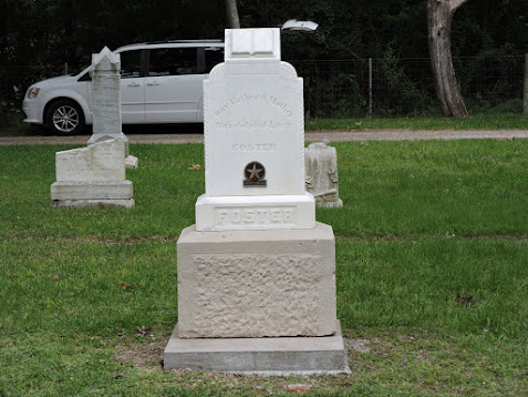
I want to thank Tom Green, KSJ Sons of the Republic of Texas, for sending me the article below on Randolph Foster, one of the Old 300. The Foster Family and Old Foster Community Museum hosted a dedication of an Old 300 grave medallion on Randolph Foster headstone in the Fulshear Cemetery. Click on the image below to view photos of the ceremony. (The relevant photos are #2 to #11 in the photo album.)
  
Randolph Foster Grave Medallion ceremony.

Tom participated in the ceremony and became interested in Randolph's story, so he did some research and wrote this short, but informative article.

History of Randolph Foster

ONE OF STEPHEN F. AUSTIN’S OLD 300


Randolph Foster was born March 12, 1790, in the Natchez District of Spanish West Florida, later known as part of the state of Mississippi. He served with his long time Texas neighbor, Capt. Randal Jones in the War of 1812, probably in the Canoe Fight on the Alabama River. In 1821, when he heard about Moses Austin’s plan to bring 300 American families to Texas, and Randolph Foster came to Texas with his parents, John Foster and Rachel Gibson, and their other children, including his brother Isaac Foster, making the Foster family one first of the Old 300. On July 16, 1824, Randolph Foster received a 4,400 acres land grant in what is now Fort Bend and Waller counties. Randolph Foster had married Lucy Ruffin Hunter, born on 23 June 1804, in Wilkinson County, Mississippi before 1821, and before the family came to Texas. Randolph Foster was a great hunter and stories exist about his hunts with Stephen F. Austin, and during the Texas Revolution, Uncle Ran, as he was known, provided meat and other supplies to the Texian Army.

On October 11, 1835, Randolph Foster was sent by Richardson R. Royall to William Stafford’s plantation, for whom the present town of Stafford was named, to retrieve 800 pounds of lead for the use of the Texian Army. In April of 1836, when Capt. Wiley Martin’s company was sent to the Fort Bend area to prevent General Santa Anna’s Mexican Army from crossing the flooded Brazos River, Randolph Foster joined Capt. Wiley Martin’s company, which consisted of only 46 men. There were at least 1,500 in Mexican Army, and the task of preventing the crossing of the Brazos River was impossible, but the delay was enough time to allow the newly formed Republic of Texas government to leave Jane Harris’ home in Harrisburg before General Santa Anna arrived. The delay in crossing the Brazos River resulted in General Santa taking 750 of his Calvary to Thompson’s Ferry to cross the Brazos River. The leader of Mexican Calvary was Col. Juan N. Almonte, who was one of the few Mexicans who spoke English, so the other Mexican Calvary hid in the trees, while Col. Almonte impersonated a Texan and convinced the Thompson ferry operator to bring the ferry over the Brazos River, where the Mexican Calvary came out of the trees, commandeered the Thompson Ferry and crossed the Brazos River flanking Capt. Wiley Martin’s Company and forcing them to retreat. This was the event that separated General Santa Anna from the bulk of his army, and when General Sam Houston learned of the separation he turn his army south at New Kentucky and head for Harrisburg, and later to San Jacinto. While the efforts of Capt. Wiley Martin’s men at the Brazos River was considered a failure at the time, this event changed history and was the main reason the Battle of San Jacinto occurred at the battle site.

Randolph Foster helped guide and protect the women and children during the Run-Away-Scrape. He continued to live in the Fulshear area until August 18, 1878, when the 89 year old pioneer died at the home of his daughter, Mary L. Foster, who had married Thomas Blakely, the Sheriff of Fort Bend County. A local school has been named the John and Randolph Foster High School, and on May 18, 2017, the family, who are almost all members of the Old 300 Society, dedicated an Old 300 marker for his grave.

Tom Green, KSJ
2718 North Larkspur Circle
Pearland, Texas 77584
(713) 340-1965

I wanted to mention the Sons of the Republic of Texas are reviving their chapter in Richmond. It has been dormant for a few years, and they want to restart it. If you can trace your ancestry back to the Republic of Texas, you can become a member. 

They are hosting an initial meeting at Joseph's in Richmond on July 20th at 6:30. Everyone with an interest and an ancestor in Texas between 1821 & 1845 is welcome.

Of course, the Daughters of the Republic of Texas have a proud organization, too. Their Richmond chapter is very active. If you have an interest in their organization, comment on this blog and I'll send you info.

Sunday, April 16, 2017

Historic Preservation: Margaret Bowie Home on UT Austin Campus

The last round of posts included a photo album of College Station, so I thought I should reciprocate with an item related to UT. The oldest structure on the Austin campus is a home that originally belonged to Margaret Bowie, widow of Rezin Bowie and sister-in-law of his brother Jim. The home was built in 1853, and was occupied until the early 21st century. 

As you'd expect, the house has been remodeled extensively and has deteriorated since it became vacant. Preserving it is a difficult issue, as explained in this article in the Austin American-Statesman.

Sunday, April 9, 2017

Some Texas Revolution History

October to April is an important interval in Texas history, and we're rapidly approaching its culmination in a few weeks. I've been reviewing some early Texas memoirs and want to post a few items that may pique your interest.
 
The first is from Noah Smithwick's book, The Evolution of a State, Or Recollections of Old Texas Days. I've posted a passage before, but I thought this was a good chapter.  It's not long, but it give a snapshot of life during those times. If you read the chapter to the end, you'll see he mentions a musical instrument called a 'clevis.' I haven't found a good definition, but my best guess is that it was a forked/cleft object with a flexible leather strap or string strung between the two tines. The player would pluck it and, maybe, control the pitch by changing the tension on the strap or string. If I'm correct, it must have made a 'twanging' sound. (I guess you go with what you've got.) Click Smithwick's photo to read his memoir.
   

The second item is a chapter from the memoir of John Crittenden Duval, a survivor of the Goliad massacre. His escape is quite a fascinating tale (to me), but even more harrowing is the William Hunter's story, which Duval recounts. Hunter was shot, stabbed, his throat cut, and his face beaten badly with a musket, but he survived and fled eastward to safety. Even then, he would have been recaptured and killed if a sympathetic Hispanic woman hadn't helped him. The link below starts with his escape after the captives were massacred, but you can begin earlier in the book if you wish. (The link should show a complete copy.)
   
 
This last item is more relevant to Fort Bend County. About this time in 1836, Santa Anna's army was moving through our area. I've provided a link to Clarence Wharton's History of Fort Bend County, where he takes up the story and cites Juan Almante's journal. (Almante was a Colonel in the Mexican Army.)
 
Once again, the link accesses the whole book, but if you want to skip to Santa Anna's foray into central Fort Bend, go to page 72 in Chapter VII, entitled The Revolution. Click the image below to access the book.
   

Friday, March 10, 2017

Texas & Beyond

People have recently sent me a couple of items about topics beyond Sugar Land and Fort Bend County.  I thought I'd pass them on.

My aunt, Mayme Rachuig Hause, sent the first one to me.  It's about the lone surviving Republic of Texas boundary marker in East Texas, indicating the border between the US and the ROT.  How unique can you get?  Click here to read the article.


The second item came from John Frierson. It's a series of postcards, showing Ford Motor Company's River Rouge plant in Dearborn, Michgan in 1927, I think.

Monday, October 31, 2016

US & TexasHistory

Thank you Bettye Anhaiser for donating this historic newspaper to the Sugar Land Heritage Foundation. I've forgotten where she found it, but it's good item. Notice it comes from the final edition of The Houston Post published on December 8th, 1941. I'll post more from this paper when we get closer to the historic day.

The Houston Post, December 8, 1941

If any of you are Facebook users, I highly recommend the Traces of Texas Page. Lots of interesting things there; these two items for example.

The Traces of Texas quote of the day comes from legendary rancher Charles Goodnight:

"When the Indians robbed houses they invariably took all the books they could find, using the paper to pack their shields. They knew, as well as we did, the resistance paper has against bullets. Paper offered more resistance to a bullet than anything to be had upon the frontier, unless it was cotton. The Indians knew this and stole all the books and paper they could find ...

Their shield was made by forming a circular bow of wood two or three feet across, over each side of which was drawn untanned buffalo hide from the neck of the buffalo, the toughest and thickest they cold get. They filled between the hide with paper. In times of action, the Indian had this on his elbow and always aimed to keep it at an angle between you and him. Very few of the old fashioned rifles would penetrate these shields. The rifle I carried then [1861], and still have, would knock a hole right through them at any angle. I once shot an Indian down on the Quitaque. I did not kill him, but he dropped his shield. Between the folds of hide was a complete history of Rome, and the boys had considerable fun passing the sheets around and reading them.

----- Charles Goodnight, as quoted in the Panhandle-Plains Historical Review, 1928
The next item is rather long, but worth the effort. It's an interview published in 1902 of a woman who was 104-years old at the time. Her name was 'Grandma Ziff' Dockery.  What a character.


 'Grandma Ziff' Dockery (photo from Traces of Texas)
 
 Shady Grove Cemetery, Pattonville, Texas (photo from Traces of Texas)

Click this link to read her 1901 newspaper article. 

Friday, October 14, 2016

Texas History: Galveston & the Alamo

I received the following note from Wanda Skidmore Benge (DHS '69) after I posted the videos of the 1900 Galveston Storm.

Chuck,
Your story about the infamous Galveston Hurricane reminded me of Ron's (Wanda's husband's) grandfather. Thaddeus Parsons, was a General Contractor on Galveston Island.
Thad hauled granite from the Texas Hill Country to build the Galveston Seawall. He invented a dump trailer to haul and dump the granite much easier, and he received a patent for this trailer. 
So, when you see that pink granite in the Galveston Seawall, it came from the Texas Hill Country. Thad was originally from Center Point, TX, in the Hill Country.
Of course, I think, he was a very handsome man. (See the first photo below.) And, I married one of his handsome grandsons. He had 14 children and 39 grandchildren.
Thad Parsons, bought (the home shown in the second photo) in March 1928 and owned it until 1967. It was one of the few homes that survived in infamous 1900 Hurricane. It sits behind Sacred Heart Catholic Church and they think the church protected this particular home. Hence, the reason Thad purchased this home for his large family of 14 children.
This home was designed by the premier architect of Galveston Island, when it was constructed in 1876. Nicholas Clayton built this home originally for the Lemuel Burr Family.
The current owners, the Floyd Pollock Family have completely restored this home to its originally glory. It is a historical home and sometimes it is on the Galveston Home Tour.
Every Mother's Day weekend and the weekend before, approximately 10 homes are on the Tour. A VERY fun tour to go on with your Mother, friend, etc
This home is considered one of the most beautiful homes in the entire Southern USA. It is a quite lovely old home. The Pollocks have outdone themselves with the restoration to this home.
It is now 140 years old. Still standing and people still living in it on a daily basis. It has survived many hurricanes as Ron's grandfather had hoped.
Wanda
Thad Parsons.

Former Parsons Home.
  
I read the following article about Adina de Zavala on the Texas General Land Office Web site. Her story is not well-know but should be. Click here to read the article. 

Sunday, July 31, 2016

Toubin Park, Brenham, Texas

I want to thank Brenda Albers Miles (DHS '66) for telling me about this park and a network of historic cisterns in Brenham, Texas.  I told her about an archeological project the Fort Bend County Historical Commission is doing in Richmond.  We're excavating an 1850s cistern in Lamar Homestead Park.  We're hoping to find artifacts from Lamar's residence.

Anyway, Brenda told me about this network of cisterns in Brenham, which was completely new to me.  I want to take a look one of these days.  Click here to read a short article on Toubin Park and the story of the cisterns.  Click here to read another article on the history of the cisterns.  Note that the 1879 pumper was designed to pump water from these underground tanks when putting out fires.


Thursday, May 5, 2016

Miscellany


My brother Bruce found a reference to the 'weather eye' that sat at atop the Texas National Bank Building in downtown Houston.  I assume the building had a Main St. address, but it was located next to the First Methodist Church.  Info says the weather eye began operation in 1957.  I found two photos to refresh your memories.


The weather eye (ball at the top of the sign) provided a simple, highly visible forecast of Houston's weather, as explained in the lyrics of an ad the bank ran on local radio stations:
Red light warmer weather
Blue light cooler weather
Green light no change in view
Blinking light, rain is due.

I may be dreaming, but I think they may have run a television ad with the same jingle.  Regardless, I remember seeing it when we drove up Main St. to shop at Foleys.

I found the following map showing the empresario land grants authorized by the Mexican government when Texas was still part of Mexico.  We tend to focus on Austin's colony, but you'll see that many other empresarios colonized Texas.  Click on the image to view other maps.


I want to thank my aunt (Mayme Rachuig Hause) for sending a link to this short film from the 1920s, entitled "Oil Field Dodge." It shows a Dodge automobile plowing through rough terrain to reach an drilling site out in the boondocks.  

Of course, the purpose of the film was to show the robust nature of Dodge vehicles, but it's important to note that roads were pretty bad back in the 1920s.  Prior to 1927 when it was paved and renamed Highway 90A, the road from Houston to Rosenberg and points west could become so muddy that teams of mules were needed to get cars out of boggy areas.

Tuesday, April 5, 2016

Char House & Groesbeck Brick


The Sugar Land Heritage Foundation has a copy of the Texas Commercial News printed in Sugar Land on December 12, 1925.  It contains an article on the newly completed Char House, which you can view in its entirety by clicking on this link.

I have taken the following excerpt about the brick used in its construction.  

The Char House, just completed, is built of brick. One million blocks of burned clay furnished by the Groesbeck Standard Brick Company and shipped from their plant at Groesbeck, Texas; selected for their quality -- their beauty in appearance. Their color is a bright cherry red, non-scumming, very attractive, but insignificant all when compared with the actual quality of the product within itself.

The "Groesbeck" Brick is noted in Texas and over the south for its hardness of texture -- its low absorption. In meeting the tests layed down by the American Society for Testing Materials, it rated 319% higher than their requirements called for in compressive strength. 20% higher in modulus of rupture (cross bending strength) and showed to have three percent less absorption. The last figure is nine percent lower than that exacted by government architects in the erection of Federal Buildings.

The "Groesbeck" Cherry Red Face Brick is made in three styles and textures, different from the square cornered smooth texture product used in the Char House. A round edge face brick, matte face brick and a ruffmingle complete the quartet. The latter is an entirely new product introduced in the first part of this month and designed particularly for the new irregular styles in residence construction.

These four separate products, three of which are Face Brick, have grown from the reputation of the old brick manufactured at Groesbeck and sold for years in small stock quantities for lumber yards.

The present management under the leadership of A. M. Smith, for years associated with the brick industry in Texas, has within the last two years greatly enlarged the plant, modernizing it in every respect, and is now one of the leaders in the brick industry in Texas. Millions of their product are distributed annually within Texas, with large shipments into New Mexico, Arkansas, Louisiana and Oklahoma, in many cases where the freight is larger than the cost of the product itself.

Tuesday, March 29, 2016

Miscellany


This first item is roughly a month late, and the image quality isn't as good as I'd like it to be, but I saw this map on Facebook and thought it was informative.  It shows the Alamo as it looked in February 1836 with an overlay of modern streets.

As you can see, the Alamo was much larger than we imagine.  I think the State of Texas has acquired the land on the west side of the plaza where Ripley's is located.  I think their intention is to eventually reconfigure the plaza so it's closer to its layout in 1836.

I recently read Blood of Heroes by James Donovan and finally understood that the main entrance to the Alamo complex was on the south side, where Jim Bowie's room is noted on the map.  The other thing I didn't realize is that the main part of the battle did not occur at the west wall.  The north wall and east wall were the site of the most intense attacks on the final day.  An attack from the south and a late surge at the west wall occurred at the very end.
   
 
A fellow who posts photos on Facebook under the name Traces of Texas posted the following, which show Rollover Pass in 1957.  (The pass is on Boliver Peninsula several miles east of the ferry landing.)  

I never realized that Rollover Pass got its name from smuggling.  The pass was a strip of land where the peninsula was at its narrowest.  Smugglers would land their boats in the surf and then roll barrels over the narrow spot and reload other boats with their contraband and haul it into Galveston Bay for distribution at various rendezvous.  Smugglers skirted customs at the Port of Galveston which patrolled the mouth of the bay between Galveston and Boliver.

Apparently, the pass was dredged on private land in 1955.  By 1957 it was a hot spot for fishing, as these photos attest.  Actually, it's still a good fishing spot, judging by the photos I see on Facebook.
 
Rollover Pass in 1957.

Rollover Pass in 1957.
Some of you may have read recently, that Schlumberger is moving its US headquarters out of Houston to Sugar Land.  I found this article in the September 1956 issue of The Imperial Crown, announcing Schlumberger's purchase of 1,300 acres of land in what eventually became Sugar Land's industrial park north of Highway 90A.

I had forgotten Schlumberger came to Sugar Land that long ago.
 
I could have sworn I saw Milkdrop Moe on Houston television when I was a child, but based on what I've found on the Internet, he was gone before I could turn on a tv set.  Here's what Earl Blair posted on Facebook:
  
Milkdrop Moe with Uncle Ned.
  
THE MYSTERY OF THE MISSING MILK DROP - I've been watching Houston television, off and on, since 1951. In those distant days, KPRC-TV was the only station telecasting blurry, black and white images to the rabbit ears perched precariously atop our 14" family Philco.

My very favorite Houston television personality from that time, was a large, talking milk drop -- yes, talking milk drop -- named "Milkdrop Moe."

Along with his human counterpart, Uncle Ned, Milkdrop's fifteen minute daily show basically served to introduce Crusader Rabbit animated cartoons and sell Sanitary Farm Dairies' milk. What could possibly provide a better endorsement of milk to a six year-old mind like mine, than first-hand testimony from a milk drop?? And one that peppered his salesmanship with a bounty of bon mots, to boot.

Noteworthy is fact that Crusader Rabbit was the very first animated cartoon series from Jay Ward, then partnered with the show's creator Alex Anderson, who later delighted television viewers with Rocky, Bullwinkle, George of the Jungle and dozens of other memorable animated cartoon characters. It was also the first cartoon series designed specifically for television. The initial episode—"Crusader vs. the State of Texas"—aired on KNBH (now KNBC) in Los Angeles on August 1, 1949.

Inside the cramped costume was talented comedian, Bobby Lauher (sometimes spelled Larr professionally). Lauher (1930-73) was born in Illinois, but grew up in Houston. A popular personality on KPRC-TV, he also teamed with Johnny Royal for that station's local comedy show, "The Guys Next Door." He found greater fame as part of Ernie Ernie Kovacs' ensemble and as a comedy writer providing laughs for Rowan and Martin and many others.

As memorable as Milkdrop remains in my mind, the show was only on the air for two years, 1952-53, and was a local Houston creation, which made finding memorabilia difficult. I located images of a badge and personal appearance flyer, but a photo of the pasteurized personality had proven elusive for decades.

That is, until this morning when, in one of my endless Internet searches, happened, purely by chance, to come across the below photo. Here, then, for all of you old enough to remember, is Milkdrop Moe and his pal, Uncle Ned. (See photo above.)

Saturday, November 7, 2015

Cotton Part 2: Hauling it to the Gin


Several weeks ago I posted an entry about harvesting cotton.  A college friend of mine grew up on a cotton farm just east of Lubbock, and he explained to me the differences in growing and harvesting cotton up in the South Plains versus here on the Gulf Coast.  He said harvested cotton up there is much dirtier than down here.  This picture from the 1950s shows why.  The lack of water means lots of bolls grow very low to the ground and become contaminated with soil.    Down here the plants grow taller with plenty of rain, so the bolls aren't nearly as close to the ground.
 
 
He also explained the 'evolution' of cotton hauling.  The photos I've shown in the past showed old-style wagons with sides made of wooden slats or chicken wire.  Here are two types of wagons; first, the old style with slats and then a more modern version with sturdy wire grating.  (The donkeys are my fiend's wife's pets.  I understand they live a life of luxury.)


Sometime in the late 1960s or early '70s gins and farmers began using 'rickers,' which produced ricks or compressed piles of cotton which were left in the fields.  These ricks were not tightly compressed or wrapped with a covering, so they were subject to damage by wind and rain. The gins sent mobile units that collected the ricked cotton and hauled it to the gin for processing.  I'm sure there are farms and gins who still use this technology.  Here are two photos of rickers.


Here are two photos I've posted in the past, showing cotton 'modules,' the newest technological advance.  The harvester compresses the cotton and puts a covering around it.  Notice they are rectangular cuboids, large rectangular blocks.  Gins have tilting flatbed trailers that can pick up these blocks and haul them to the gin. 
 

Indianola, A 19th Century Gateway to Texas

I know one, possibly more, of my ancestors immigrated to Texas through Indianola on Matagorda Bay.  August Wilhelm Rachuig sailed from Bremen, Germany in 1868 and soon after landing headed for Washington County, where he had friends and, we think, relatives.  As a consequence, I'm interested in the history of the 'ghost' port.

The Lake Jackson Plantation: Growing & Milling Sugar


I found the following online article about the Lake Jackson Plantation.  It gives a brief description of the plantation's history.  Note that it once included the Retrieve and Darrington estates, which eventually became prison farms.  It also summarizes the way sugar plantations operated.

The article is five pages long.  If you're interested in the history of the Texas sugar industry, the process of making sugar, and archeology, be sure to follow the additional links at the bottom of each page.

Monday, August 24, 2015

Highway 90A Completed in Sugar Land, 1927


I mentioned in the last batch of posts that this year marks the 100th anniversary of the Old Spanish Trail, known as Highway 90A here in Sugar Land.  Further research has turned up more information, but not as much as I'd hoped.  

I need to locate issues of the Texas Commercial News published in Sugar Land to get the local view of the highway program, but here is what I've learned from other resources.

A Houston Post article published in July 1919  said the exact route of the OST hadn't been determined, but it would likely follow the Southern Pacific rail line.  I read in another source that the railroad was critical to the project due to its right-of-way and its role in delivering men and materiel to construction sites.

In October 1919 the Old Spanish Trail Association received a charter from the State of Texas and had started local organizations in most of the counties in the states through which the highway would pass.  Since the State of Texas encompassed (by a wide margin) the largest segment of the 2,800-mile highway, and since San Antonio was the approximate mid-point, San Antonio was selected as the OST Association's headquarters.  Their offices were located in the Gunter Hotel.

Despite all this activity there was little real improvement completed in 1919 on the local roads that became the OST.

1921 newspaper article highlights road problems.
 
Naturally, the Texas Highway Department (THD) played a major role in this program.  THD was the precursor to today's TXDOT.  It was created in 1917 to take advantage of the 1916 Federal Road Aid Act, which granted funds to states that centralized control, construction, and maintenance of their roads.

 Road paving in Sugar Land, 1927.
 
Road paving near Sugar Creek Boulevard, 1927.

In 1925 THD relieved counties of road maintenance.  Counties were still obligated to obtain rights-of-way for new roads, however.

 Cars waiting just east of Eldridge Road to pass through Sugar Land after opening ceremony, 1927.
 
  Cars & passengers waiting just east of Eldridge Road to pass through Sugar Land after opening ceremony, 1927.
 
In 1925 State Attorney General Dan Moody charged Governor Ma Ferguson's administration with corruption and malfeasance in its handling of road contracts.  Moody won his case and became the next governor, although Ma Ferguson returned to office in the 1930s.
 
Paving in the center of Sugar Land, 1927.

As you can see from these photos, many of which I've posted before, 1927 was a big year for Sugar Land's main highway.  Highway 90A was paved as a two-lane road through town and across Fort Bend County.  In 1947 two additional lanes (handling east bound traffic) were completed.  So it goes. 

 W. T. Eldridge, Sr. in passenger seat of lead car (a Rolls-Royce), 1927.
 
I. H. Kempner, Sr., W. T. Eldridge, Sr. and other dignitaries at ribbon cutting, 1927.