Drop Down MenusCSS Drop Down MenuPure CSS Dropdown Menu

Monday, January 2, 2017

News & Updates

I was swamped with other duties over the last two months, so items have piled up. I'll eventually get to them, but for now I want to mention just a couple of items. First, Mark Voss (DHS '71) died suddenly last week. Click here to view an obituary. I had no idea he had worked in Afghanistan. I have recent photos of Mark in the More People of Old Sugar Land posting immediately below.


Mark Voss.

My classmate (DHS '68) and good friend, Sam McJunkin, lost his wife Hilda suddenly last month. Click here to read an obituary. Some of you will remember Sam's father was a druggist at the Sugar Land (Rouse's) drug store. Sam's mother Hazel was the City of Sugar Land's first Secretary. Sam's sister Olive is a Dulles alum (Class of '63).

My sincerest condolences go to the Voss and McJunkin families. 

On a brighter note, I want to wish Shirley Laird a very belated, but happy birthday. The big day was November 15th. I don't want to make a mistake, so I'll say she's either 93, 94, or 95-years old.  But, who's counting?  Happy birthday!

I will have more on this later, but I wanted to congratulate the City of Sugar Land and Pat Pollicoff, Director of Communications, on the new state historical marker at the Imperial Prison Farm Cemetery in Telfair. I participated in the dedication ceremony and thought it was well done.

More People of Old Sugar Land

Click on the image below to view a photo album of more people of old Sugar Land. I've added captions, which you can view by clicking the 'i' icon in the upper right of the display.
 
Photo album of old-timers.
 

More Views of Old Sugar Land

I've been reviewing several old documents over the past couple of months and came across two items I wanted to post. I may have posted the first one, but it's worth repeating.  It shows a layout of The Hill, dated February 18, 1919.

Note the numbering of the street names. What we now know as First Street was labeled 'Boulevard.' Actually, Boulevard or First Street was undeveloped at the time this drawing was made. We know it wasn't created until four or five years later. 

Also notice that the first four homes on the west side of Main Street and the homes on Boulevard are just sketched in. All the other homes have numbers assigned to them. This another indication of the progression of development that occurred during the early 1920s. The first hospital shows more detail than I expected. (It was built in 1924.)

Click on the image to enlarge the view.


The next drawing shows development that never occurred. (The title of the drawing is 'Map of Sugar Land Improvement Company's Addition to Sugar Land, Texas.') I can't find a date, but I can tell the drawing was made before 1924. Had Sugarland Industries executed this big plan, the town would have developed eastward in its early years. Our current industrial park would have been a residential district.


This next set of images comes from aerial photos taken in 1941. (I've posted selected images from this set in the past.) These images show the town on April 5, 1941. Click on the images to magnify them.

The first shows a view of the center of town. You can easily see Highway 90A and the loop Oyster Creek makes around Mayfield Park and the refinery.

Sugar Land on April 5, 1941.

Here is a blow up of Mayfield Park. Note the track. M. R. Wood School was the set of structures north of the track. (The school would undergo significant expansion in 1953.) Also note that houses abut the refinery's northern perimeter. (I'm not certain there was a fence, but I assume there was one.)

Mayfield Park on April 5, 1941.

The next magnification shows the east side of town. I've added some annotations to identify particular structures and sites.

East Sugar Land on April 5, 1941.

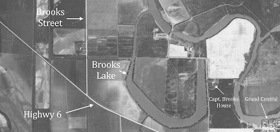
The next zoom shows Brooks Street. I've added annotations to this photo, too.  Notice the first two homes on the west side of Brooks Street. They would be moved a few years later when Guenther Street was extended westward. I believe Dr. Carlos Slaughter lived in the first house.

Sugar Land on April 5, 1941.

These last two aerials show more of the south and east side of town.

South and east Sugar Land on April 5, 1941.

This magnification highlights a few locations in the photo. Of course, that area is not nearly as empty 75 years later.

South and east Sugar Land on April 5, 1941.

Photos of the Imperial Sugar Refinery

I'm not sure of the date for these photographs, which come from the Sugar Land Heritage Foundation's collection. Maybe someone can make a better guess, but mine is sometime in the early 1970s. I thought they have artistic merit although there are imperfections in a couple of them. Click the image below to see the album.


The SLHF has closed its temporary location and will reopen this summer in its permanent location. The SLHF museum will be located just behind the silos at Imperial Market. The Fort Bend's Children's Discovery Center occupies the 1st floor of the building. The SLHF museum and the City of Sugar Land's Visitor's Center will occupy its second floor.

The SLHF sells images of historic photos and documents in its collection. If you are interested, review their Web site. If you want an image you don't see in their store (maybe one you've seen on this blog), call and ask if they can provide what you want.  Their number is 281-494-0261.