Here is a short video I made of a new acquisition at the Sugar Land Heritage Foundation/Museum. I think it's self-explanatory, so I won't add anything here except to say thanks to George 'B. I.' Webb for his generous donation of a unique part of Sugar Land's history.
Monday, April 29, 2013
White's Cafe
Sugar Land had a few dining options in its early days. During the 1940s and '50s White's Cafe was a popular option. Here is a brief history with photos from an edition of The Houston Post printed in January 1952. It featured a section on Sugar Land's new shopping center on Highway-90A across from the refinery.
The top photo in the ad for White's Cafe shows what many residents called 'The Root Beer Stand.' It was located on the land where the 'new' shopping center was built. The lower photo shows the Cafe on the corner of Ulrich and Highway-90A west of The Palms Theater. (It's the restaurant I knew; several proprietors, including Herbert Haas, Marshall Durr, and the McGinnes family ran it through the years.)


The Post feature included the following short article on J. B. Fowler.


Old Dairy Cow Bridge
There are several dairies in Sugar Land's history. During the Cunningham years a dairy was located near the intersection of Brooks and Guenther Streets. The Sartartia Dairy (today's New Territories) was very well-known and included a popular ice cream parlor.
Sugarland Industries had a town dairy (providing home delivery to Sugar Land residents) in the first half of the 20th century. It was located on the west side of Ulrich Street just north of its intersection with old Imperial Boulevard. The barn and other buildings were located south of Oyster Creek. The cows grazed north of the Creek, so the Industries built a wooden bridge for them to reach their buffet table.
If you've driven to Constellation Park from Ulrich, you've passed through the old dairy. Here's a Google map showing the area today.


Here's a photo of the dairy cow pen in the 1930s. You can see the bridge in the background. (Mayfield Park is on the right; the cow pasture is on the left; Constellation Park is a few hundred yards out of view on the left.)

Dam #2, or Coburn's Dam During 1935 Flood
I've been looking at old photos recently and found some with good annotations on them. I've seen the following photos before, but there was never an indication of date and location.
I've learned these were taken during a flood in 1935 at Dam #2, or Coburn's Dam as we referred to it. (It's located at the end of Oyster Creek Drive.) It was a reliable place to find fishing minnows, especially 'red horses,' which were prized bait.
Here's a Google map showing the location today - note the red rectangle.

I think the first photo was taken with the camera pointed southeast. The water is rushing 'down stream' toward Stafford.
Here's a Google map showing the location today - note the red rectangle.

I think the first photo was taken with the camera pointed southeast. The water is rushing 'down stream' toward Stafford.

This next photo was taken looking southwest toward the location of the Fluor complex.

Wednesday, April 3, 2013
Happy Birthday, Ernest Trevino
Ernest Trevino (SLHS '54) celebrated a birthday last month. Carlos Tarver (SLHS '53) asked me to make a DVD for Ernest in honor of his birthday. Here is a short clip from the video, which focuses on Ernest's athletic career at Sugar Land High.
Ernest is enjoying life as a retiree from Imperial Sugar. I think he can still run a quarter mile in under a minute. (I know I can't.) Those of you who know Ernest can wish him a belated happy birthday next time you see him.
Sip and Stroll at the Imperial Refinery Site on April 27th
Sugar Land's annual Wine & Food Affair is a 5-day series of events, which runs from April 24th to April 28th. The event on Saturday is a Sip and Stroll on the old Imperial Refinery site. Local chefs and other food vendors will offer the public a chance to sample their fare. Click this link to view details. (You can navigate to pages explaining other events.)
The Sugar Land Heritage Foundation will open the Sugar Land Museum to visitors during the event and will display historical photos through the strolling area, which consists of the 1st floor of the Char House and the Three-Bay Warehouse.
Of course, a large part of the refinery complex was demolished a couple of years ago, anticipating redevelopment of the site. Here are a few photos from the Museum's archives that show how the refinery looked in its heyday.
The two photos below show a 'sip and stroll' from 1948. Actually, it's a company picnic on the refinery grounds. These pictures show guests lining up at the serving lines at the west end of the Three-Bay Warehouse. This area is now covered with a modern extension of the Warehouse.


The next two photos show the same area as it looked during a normal working day in the 1950s. The trucks are backed up to the dock where the food service tables were located in the 1948 pictures. The second picture shows men loading the trucks with sacks of Imperial Sugar.


The next photo shows the west side of the Power Plant, which stood northeast of the Three-Bay Warehouse. (This photo was taken in late 1940s.) The Power Plant has been demolished, but the two smoke stacks on the right of the picture still stand on that exact spot.

These last two photos show buildings that were part of the refining process. The first picture wasn't labeled. Someone will probably correct me, but I think it is the Pan House. (Update: This is the Water Treatment Plant next to the Power Plant. It treated water used to produce steam in the refining process.) An annotation on the second picture said it was the Remelt House. Both pictures were taken in 1950.


Tuesday, April 2, 2013
Picnic at the Foster Community Museum on May 5th
The Foster Community Museum between Richmond and Fulshear is hosting a picnic on May 5th. Many people may not know it, but the Foster community has a connection with Sugar Land. Sugarland Industries owned a large estate in the area. It was called Foster Farms. In fact, the Kempner family still owns some of the property.
It was a farming and ranching operation that lasted into the 1950s. From the later decades of the 19th century into the early 20th century, landowners in that area grew sugar cane which they sold to Imperial Sugar for milling and refining.
The picnic sounds like a great opportunity to enjoy some spring air in bucolic north Fort Bend County.
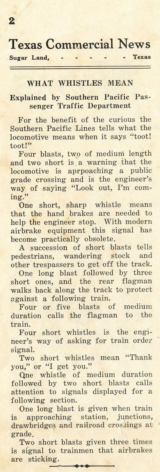
Train Whistle Explanation, 1924
From 1913 to the early 1930s Sugarland Industries printed a newspaper that included local news. Over most of its life the paper was known as the Texas Commercial News. (I've posted excerpts on this blog in the past.)
The issue dated December 6, 1924 included the following short article explaining the various train whistle patterns local residents may have heard when trains passed through town. I guess train noise has always been a problem in Sugar Land.
Senior Citizens Dance at Clements High School, April 6th
The National Honor Society at Clements High School is hosting a dance for ALL senior citizens on Saturday, April 6th, at the school's commons. If you have a connection with Clements High School, or want to boogie with your demographic, let them know you'll be there.
Subscribe to:
Posts (Atom)