Drop Down MenusCSS Drop Down MenuPure CSS Dropdown Menu

Monday, April 30, 2012

Photos from Sugar Land Skeeters' Opening Weekend


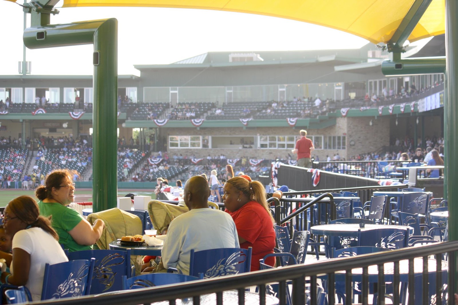
Bruce's son-in-law took these pictures when he and his son attended Saturday's game in the Skeeters' debut series with the York (PA) Revolution.  I hope to have some video from the inaugural game ready in a few days.


Right field grass seating.


Children's play area behind outfield wall.


Patio seating behind left field wall.


Sky boxes.


Old Whip and the Battle of San Jacinto


Felipe Rodriguez, a student at the University of Mexico's school of veterinary medicine, recently posted a message on the Fort Bend Museum's Facebook page.  He wondered if we knew the story of 'Old Whip,' a horse made famous in the Runaway Scrape and Battle of San Jacinto.  I had to admit that I'd never heard his story and would research it.  I found several sources, including contemporaneous accounts of the Runaway Scrape, and boiled down them down to this abbreviated version.

William Vince was one of Austin's Old 300 colonists. His 3 brothers were also colonists.  Their land grants were in Harris County south of Buffalo Bayou and east of Harrisburg -- roughly where South Houston & Pasadena are now located.  William also possessed a smaller farm near Arcola.  I haven't located it precisely, but he was a neighbor of Francis Marion Fenn, so it was somewhere in the Fresno-Arcola-Rosharon area.

William Vince had a black, high-spirited, fast horse he kept on the farm.  Vince called him Old Whip possibly because he could whip all other local horses in a race.  Horse racing was a big past-time among the colonists.  Churchill Fulshear and (later) Frank Terry were big horse-racing enthusiasts, so fast horses were renown.

I've provided a map that shows the the paths of the various Mexican armies and the Texian army.  The map is missing some details, but it will do for the purposes of this story.  


You can see the path of Santa Anna's corps as it moved from Richmond to Stafford's Point.  From there he moved northeastward to Harrisburg to capture the rebel government. As they made this leg of the journey, Santa Anna passed by Vince's farm and 'requisitioned' Old Whip and Vince's $300 saddle. The situation was chaotic -- fleeing colonists took what they could and left what they couldn't carry or herd before them.  Vince may have been preoccupied with other things, or maybe he was seeing to his main plantation near present-day South Houston -- for whatever the reason, he left Old Whip and his saddle for Santa Anna to plunder.

At this point Santa Anna pranced around on Old Whip and felt pretty good about defeating the rebels even though the provisional government had left Harrisburg before he arrived there. Santa Anna believed the government had fled further eastward to New Washington, so he pranced toward Galveston Bay in pursuit.

Although it doesn't appear on this map, Sims Bayou was a long and relatively wide tributary flowing into Buffalo Bayou from the south.  I believe it meets Buffalo Bayou in Pasadena or Deer Park.  The point is that it was deep and wide and required a bridge to cross.  In fact, William Vince had built a bridge where Sims Bayou bisected his property.

Santa Anna crossed William Vince's Bridge while Sam Houston trailed his army on the north bank of Buffalo Bayou.  Eventually, Houston committed his army and crossed Buffalo Bayou to the south bank and turned eastward also crossing Vince's Bridge, but he ordered Deaf Smith and his scouts burn the bridge once they were all across the Bayou.  When Houston moved his army to the north end of the San Jacinto Battle Ground, he had actually hemmed Santa Anna's army in a trap.  The route west was blocked because Vince's Bridge was destroyed.  The route north (Lynch's Ferry over the San Jacinto River) was blocked by Houston's army.

You know what happened on the 21st of April.  When Santa Anna finally woke up from his nap, he hopped on Old Whip and galloped west, thinking he could get over the bridge and ride to Richmond where a large contingent of his army was camped in reserve.  Well, he found the bridge burned and tried to ride across on Old Whip, but the horse got mired in the muck and couldn't get out.  Some accounts say Old Whip knew where home was and plunged into the Bayou with Santa Anna hanging on for dear life.  Regardless, Santa Anna jumped off Old Whip and ran into the weeds where he hid for a day or so. 

As we all know, he was taken prisoner and ended up visiting Washington before repatriation to Mexico.  Old Whip was pulled out of the mud, cleaned up and celebrated throughout the colony.  Jesse Ziegler says in his book, "Wave of the Gulf," that Old Whip lived a long and happy life.

Felipe suggests we honor him with a statue somewhere in Fort Bend County.


Miscellaneous Old Photos


Beverly Lampson put me onto a Facebook site ("Southwest Houston - Do You Remember When?) with some great pictures of old Houston.  Many of them are personal snap shots of life in the  '50s & '60s.  Here are a sampling of a few things I liked.  

Those of you my age will remember the Fort Bend County Library's Book Mobile.  It made semi-monthly (I think) visits during the school year.  When I attended Sugar Land Elementary, it stopped on the driveway between the circles about where the tennis courts stood.  This won't make sense to youngsters, but it will to old timers.


In early 1962 the Houston Sports Association, owners of the Colt .45s, put up a temporary building by the old Colt Stadium construciton site.  They wanted to promote the club before the season started in April.  They had souvenirs and all types of marketing stuff,  some of it free.  I remember nagging my father into stopping one Sunday afternoon.  I picked up a handful of round, orange-and-blue decals with the Colt logo on them.  Bruce & I put them on the windshield and windows of my dad's work car.  


I recall putting one on the front windshield where it obstructed the driver's (Dad's) view.  When he got back from work on Monday afternoon, I saw the crinkled remnants of the offending decal clinging to the windshield.  My dad gave us/me a mild lecture on the importance of an unobstructed view through a car's windshield.  Here's a picture of the building where we got the decals.


One last baseball-related item since baseball is the theme of the week.  The Facebook site had this picture & article about a game between Ellington Field and Hughes Tool at old Buff Stadium.  I don't have a date, but it must be from the early '50s.  My guess is this game was not part of the Post's semi-pro baseball tournament played each summer until 1952.  I assume the teams played in Buff Stadium while the Buffs were on the road.  I'll bet the Fort Bend Jaybirds played both teams.


Monday, April 23, 2012

History in the Making at Constellation Field in Sugar Land


Many thanks to my sister-in-law and brother for inviting me to the gala opening of Constellation Park, home of the Sugar Land Skeeters. I am very impressed with the ball park, and the fundraising gala was a big success, as you'll see in the article on the Skeeter's Web site.  My only regret is that I didn't meet Bob Aspromonte, who was in the audience that night.


The first game played in the park was Dulles vs Clements on Saturday, April 21st.  (I never heard the score until now, but I've just received 'late breaking news' from Pat Pollicoff.  The final score was Clements 9 - Dulles 2.)  I've cribbed these photos from Tommy Laird who attended the game and posted them on Facebook.


Pittsville, Texas A Forgotten Corner of Fort Bend County


I've been busy videoing different events over the past few weeks.  This 19-minute video records the State Marker Dedication Ceremony for Pittsville, a small community north of Fulshear.  It no longer exists and much of its history was nearly forgotten until the Fort Bend Historical Commission sponsored this Marker.  

Link to video of State Marker Dedication Ceremony
 
Unfortunately, the Pittsville exhibit at the Fort Bend Museum is over, but it recounted the interesting history of this small community on the northern border of Fort Bend County.  Here is a link to a brief article on Pittsville in the Handbook of Texas.
 
Here's another link to a famous, but forgotten citizen of Pittsville. Laura Krey is Fort Bend County's equivalent of Margaret Mitchell, author of "Gone With The Wind." 
 

2012 Children's Day at the Fort Bend Museum


I made this 8-1/2 minute video of Children's Day (March 24th) at the Fort Bend Museum in Richmond.  It was a free event they do annually for local children.  They have similar events (not free) in July & August, so take your kids or grandkids if you want a local diversion to break up the summer monotony.  (Check their Web site later this summer for a schedule, or call 281-342-6478 for detailed information.)


Arbuckles' Ariosa Coffee, the Starbucks of Texas Cattle Drives


During this year's spring break, I went to the George Ranch Historical Park south of Richmond and videoed some of the special programs they presented to visitors.  (I posted several videos last week.)  

This week I made an 8-minute video about the fascinating story of Arbuckles' Ariosa Coffee.  As the interpreter explains it, Arbuckles could be considered the Starbucks of cattle drives.  They found a way to keep the coffee fresh, plus they offered coupons and treats to their buyers.  There's nothing new under the sun.

Thursday, April 5, 2012

1940 Census Records for Sugar Land Area


Those of you who are interested in genealogy have probably heard that the US Census Bureau has put the 1940 Census records online.  Ancestry.com is preparing a name index, but that's a big project involving lots of volunteers.  It may take quite a while to complete.  

The only search method at the moment is by enumeration district.  Once you find the number of the district you want, you still have to look through the records one by one to find your family of interest.  It can be a tedious process, but experienced genealogists know the drill.

If you go to the Web site, you'll see instructions for finding enumeration district numbers and searching the records.  I've provided the link below.

I've also included a link to the page covering my mother's family, who lived at the Humble Camp south of town.  Their entries begin on line 25.  My mother is Sally Ann.  You should be able to magnify the image, so you can read the headings.

This census recorded interesting information about incomes, work histories, housing and relief aid.  None of that was recorded before the '40 Census.  I've spent some time looking at both sets of records that cover the Sugar Land area.  I've found many people I know.  I've found people I didn't know lived in Sugar Land as early as 1940.  

I've also got a reasonably good idea of the relative financial position of residents, but who can guess the accuracy of the income figures?  I'm sure the census workers didn't verify the figures.  Some people probably guessed or exaggerated; others probably had no bank account or pay stubs and didn't know how much they made in 1939.

Link to 1940 Census Web site.

A logistical note: I've upload a copy of my family's census page, but Google reduces the resolution to the point you can't read the small print. I left the uploaded page anyway. I've added a link (below) to the same page on the Census Web site. You can see the full image there, but it's very awkward. They don't give you zoom and shrink widgets. If you want to do effective research, the best bet is to bite the bullet and download the zipped file for the enumeration district you want. It may take a while, but you'll be able to manipulate each image and do a reasonably good review to find your family. I think searching the records online is near impossible, but they'll probably develop a more sophisticated portal later.  


Sunday, April 1, 2012

Peter Schwalbe


I want to thank Linda Hagler Mosk (DHS '68) for the following image.  She's been organizing her sister's and mother's archives and came across this obituary for Mr. Peter Schwalbe.  As Linda said, he led an interesting life.


Dulles High Class Favorites, 1965


My thanks go to Linda Hagler Mosk (DHS '68) for sending me this clipping from the Viking Shield.  I'm not sure of the exact date, but it was sometime in the spring of 1965.  Dian Hagler (DHS '65) was Linda's older sister.  Dian was elected Dulles Olympian that year.


Saturday, March 31, 2012

Old School House in Mayfield Park


I received a message this week from Carmen Flores Perez (DHS '67) asking if I had any info on the school for Hispanic children located in Mayfield Park back in the '20s through the '50s.  

I can't find the references right now, but I know T. C. Rozelle had these photos of a building that was said to be the school house in question.  (I'm still researching this topic, so I hope to get an answer.)  

I think I have a photo of the Hispanic school out at Grand Central.  I'm almost certain Roland Rodriguez, Sr. (SLHS '49) is in it.  I understand these schools were early bi-lingual programs.  Children whose primary language was Spanish and whose English was limited, attended these schools.  As soon as their Engish skills improved, they went to the main campus on Lakeview Drive.

I know from a biography of Felix Tijerina (the Houston restauranteur) that Sugar Land had a Little School of 400 in the mid-1950s.  Tijerina was the driving force in this state-wide effort.  He attended the opening of the school.  I'll dig out the quotes from the book and post them in the future.  It's an interesting story.


Sugar Land Elementary Safety Patrol, 1960/61


My thanks go to Gloria and Travis Gandy for sending me this blast from the past.  I'm pretty sure we were in the 5th grade.  We were giants in those days.

The allure of Safety Patrol was the yellow helmets.  If you had a yellow helmet, you were something.

Back row left to right: Chuck Kelly, Stephen Beer, Gerald Culler, Robert Allen, Sam McJunkin.  Front row: Billy Joe Foitik, Bobby Munson, Mitchell Hall, John Royce Holt, Matthew Hall.


100 Years of the Cowboy, Spring Break Week at the George Ranch Historical Park


This is the first in a series of short videos covering spring break week at the Park.  This first one shows preparation for a chuckwagon lunch out in the Park's grounds.


100 Years of the Cowboy, Spring Break Week at George Ranch Historical Park


Part 2 of the series of short videos covering spring break week at the George Ranch Historical Park.  This installment is a  continuation of the chuckwagon lunch.


100 Years of the Cowboy, Spring Break Week at George Ranch Historical Park


Part 3 in which Cowboys Larry & James give a presentation to visitors about cattle management techniques.

Wednesday, March 21, 2012

1940 US Census Map & Santa Anna's March Through Fort Bend County


I learned recently that the records for the 1940 US Census will be available online next month.  They aren't indexed by name yet, so researchers need census enumeration district numbers to perform searches.  (Ancestry.com will complete a name index later.)  I found the census map showing local districts for Sugar Land at the US Census Web site.

I identified what I needed for my family.  The Kellys lived in district 79-11.  The Rachuigs in 79-13.  The map shows the lay of the land in 1940 to a reasonably good degree although structures are sketchy.  (A legend for structures must exist somewhere.)

For some reason I thought about Santa Anna's sweep through Fort Bend County in 1836 as I reviewed the map.  I read Wharton's History of Fort Bend County a couple of years ago and learned the route he took.  Wharton's account is less than clear in spots because contemporaneous accounts are contradictory, but it cleared up some fundamental mistakes I grew up with.

First, Thompson's Ferry (where Santa Anna crossed the Brazos) was west of Richmond as I've denoted on the map -- not down by present-day Thompson.  Second, Santa Anna never crossed Oyster Creek.  He stayed north of Oyster Creek when he left Richmond and headed toward Stafford's Point.  Third, Santa Anna split his army into multiple groups.  (In fact, he left some troops in Richmond.)  Strictly speaking, his army took several routes eastward from San Antonio to San Jacinto.  

Here's the 1940 Census map with annotations.


Here's a Google map with roughly the same annotated path.  I wanted to overlay the two maps, but I couldn't get it to work well.  The annotations aren't exactly identical, but they're relatively close.


Fort Bend Jaybird Baseball Team


I had the pleasure of talking with Lou Payton (SLHS '46) recently as part of my research into local baseball history.  I'll have much more to post about him and local baseball, but I thought I'd post this introductory newspaper article about the Fort Bend Jaybird baseball team, for which he played in the early 1950s.  The article comes from Lou's scrapbook -- many thanks for letting me scan it.

I remember Mr. Roy Pickard as part-owner of the Rosenberg's Pickard & Huggins Drug Store.  I never knew he was a big baseball man.  Apparently, he played for the Bay City Rice Eaters back when they existed.

You'll notice the team was filled with college boys who played for the Jaybirds during the summer.  I asked Lou whether they were paid.  He said they were.  Ostensibly, they were employed by local establishments and weren't paid to play baseball, but the jobs weren't all that onerous.


This next article (from the summer of 1950) covers the Jaybirds' entry into The Houston Post's annual baseball tournament for semi-pro teams.  Games were played at Buff Stadium. (Bruce Layer was a well-known sports reporter & broadcaster in 1950.  It looks like Lou saved his press pass.)


Max Schumann, Jr. (SLHS '40)


Some of you know Max Schumann, Jr. (SLHS '40) died recently.  I thought I'd repost the Class of '40 picture, in which he appears.  I've also posted a picture his nephew, Mark Schumann, posted on Facebook.  It shows from left-to-right: Robert, Herbert, Max, Sr., William and Max, Jr.  The occassion is Robert Schumann's wedding on June 9, 1956.

Thanks, Mark.


KPRC Transmitter Located in Sugar Land, 1930


An anonymous former employee of KPRC moderates a Facebook group devoted to the history of the KPRC radio and television stations.  I recommend it highly to anyone interested in Houston's broadcasting history.  The blog includes the following photos of the KPRC transmission tower located on the northwest quadrant where Eldridge Road intersects Highway-90A.  Actually, Eldridge Road was known as KPRC Road even when I was a child.


I think I can find the exact date, but I'm too lazy to do it right now.  Anyway, the tower and transmitter building stayed in Sugar Land for a very short time around 1929/30 -- just a year or so.  I think it moved to La Porte and then other locations through the '30s and '40s.  The picture above shows a snow-covered scene from the winter of 1930.

The following picture shows the equipment room in the building.


The next picture shows the engineer and his wife in May, 1926 before their move to the Sugar Land transmitter station.


Here's what the blogger said about them:

"KPRC's first couple, Olin S Brown and his wife Ruby Jo, at the piano in KPRC Radio's solo studio on the 22nd floor of the Post-Dispatch building. Olin and Ruby both worked at the station, he as remote engineer, she as studio hostess and secretary to Alfred P. Daniel. Later they lived at the transmitter site in Sugar Land. In 1934 they moved to Dallas where Olin worked for WFAA until his retirement in 1967."

Sometime after KPRC left the transmitter station, it became the home (minus the tower) of Mr. and Mrs. A. H. Weth.  He was Chief Engineer at Imperial Sugar.
  
My thanks go to the anonymous employee moderating the KPRC Facebook group.  I would have linked directly to his photos, but I couldn't find a way that non-Facebook viewers could get access.
 

1950 Houston Buffs


I've been involved in baseball research and made contact with a group of historians who are researching a book to be published next year.  It will cover Houston baseball history from 1861 to 1961.  Of course, the end point preceeds the debut of the Colt .45s and Houston's entry into Major League Baseball.

The Buffs were Houston's minor league affiliate of the St. Louis Cardinals.  My father, his parents and his aunts and uncles were Buff fans and told me about watching Dizzy Dean, Ducky Medwick and other players who eventually became part of the Card's Gas House Gang who beat the Detroit Tigers in the '34 World Series.

The lead historian, Bill McCurdy, has an fascinating blog covering lots of Houston-oriented topics.  I saw an entry on the 1950 Buffs.  Some of you may recognize the players' names.  Jerry Witte is the only one I know.

Notice the Buffs anticipated Bill Veek and wore uniforms that included shorts rather than conventional baseball pants.