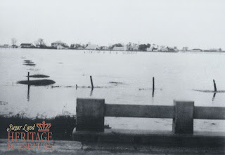
We've had a lot of rain recently. Houston and areas north of Sugar Land suffered serious flooding. We're thankful Sugar Land did not. I found some photos showing a major flood in 1935 in the Sugar Land Heritage Foundation's archive.
The disastrous 1899 and 1913 floods are better known, but the '35 flood must have been pretty bad because it happened after flood control measures (levees) had been built in the 1920s.
I'm not positive about the date of the first image, but I think it was taken in the 1920s when the levees were built. It shows a crew and a drag line at an unknown location, but the cab has a sign saying "Sugarland Insustries, Sugar Land, Texas" painted on it.
The next photo was taken after the '35 flood and shows Highway 90A west of Sugar Land. I don't know the exact location, but my best guess is near the old Sartartia Plantation. Here's a Google Street View of the possible location today - the 1935 photo is immediately below it.
 |
| Highway 90A bridge near Sartartia during 1935 flood |
 |
| Highway 90A bridge during 1935 flood |
 |
| Flooded field along Highway 90A during 1935 flood |
This last photo shows downtown Sugar Land flooded during the 1913 flood. The area in the foreground is roughly where the Farmer's Market is held every Saturday.
 |
| Downtown Sugar Land in the 1913 flood |
