Drop Down MenusCSS Drop Down MenuPure CSS Dropdown Menu
Showing posts with label State of Texas. Show all posts

Sunday, April 9, 2017

College Station & Texas A&M Photo Album

A recent edition of the Houston Chronicle contained this photo essay on College Station and Texas A&M. I thought it deserved a posting here. Click the image to view the photo album.

Tuesday, March 29, 2016

Miscellany


This first item is roughly a month late, and the image quality isn't as good as I'd like it to be, but I saw this map on Facebook and thought it was informative.  It shows the Alamo as it looked in February 1836 with an overlay of modern streets.

As you can see, the Alamo was much larger than we imagine.  I think the State of Texas has acquired the land on the west side of the plaza where Ripley's is located.  I think their intention is to eventually reconfigure the plaza so it's closer to its layout in 1836.

I recently read Blood of Heroes by James Donovan and finally understood that the main entrance to the Alamo complex was on the south side, where Jim Bowie's room is noted on the map.  The other thing I didn't realize is that the main part of the battle did not occur at the west wall.  The north wall and east wall were the site of the most intense attacks on the final day.  An attack from the south and a late surge at the west wall occurred at the very end.
   
 
A fellow who posts photos on Facebook under the name Traces of Texas posted the following, which show Rollover Pass in 1957.  (The pass is on Boliver Peninsula several miles east of the ferry landing.)  

I never realized that Rollover Pass got its name from smuggling.  The pass was a strip of land where the peninsula was at its narrowest.  Smugglers would land their boats in the surf and then roll barrels over the narrow spot and reload other boats with their contraband and haul it into Galveston Bay for distribution at various rendezvous.  Smugglers skirted customs at the Port of Galveston which patrolled the mouth of the bay between Galveston and Boliver.

Apparently, the pass was dredged on private land in 1955.  By 1957 it was a hot spot for fishing, as these photos attest.  Actually, it's still a good fishing spot, judging by the photos I see on Facebook.
 
Rollover Pass in 1957.

Rollover Pass in 1957.
Some of you may have read recently, that Schlumberger is moving its US headquarters out of Houston to Sugar Land.  I found this article in the September 1956 issue of The Imperial Crown, announcing Schlumberger's purchase of 1,300 acres of land in what eventually became Sugar Land's industrial park north of Highway 90A.

I had forgotten Schlumberger came to Sugar Land that long ago.
 
I could have sworn I saw Milkdrop Moe on Houston television when I was a child, but based on what I've found on the Internet, he was gone before I could turn on a tv set.  Here's what Earl Blair posted on Facebook:
  
Milkdrop Moe with Uncle Ned.
  
THE MYSTERY OF THE MISSING MILK DROP - I've been watching Houston television, off and on, since 1951. In those distant days, KPRC-TV was the only station telecasting blurry, black and white images to the rabbit ears perched precariously atop our 14" family Philco.

My very favorite Houston television personality from that time, was a large, talking milk drop -- yes, talking milk drop -- named "Milkdrop Moe."

Along with his human counterpart, Uncle Ned, Milkdrop's fifteen minute daily show basically served to introduce Crusader Rabbit animated cartoons and sell Sanitary Farm Dairies' milk. What could possibly provide a better endorsement of milk to a six year-old mind like mine, than first-hand testimony from a milk drop?? And one that peppered his salesmanship with a bounty of bon mots, to boot.

Noteworthy is fact that Crusader Rabbit was the very first animated cartoon series from Jay Ward, then partnered with the show's creator Alex Anderson, who later delighted television viewers with Rocky, Bullwinkle, George of the Jungle and dozens of other memorable animated cartoon characters. It was also the first cartoon series designed specifically for television. The initial episode—"Crusader vs. the State of Texas"—aired on KNBH (now KNBC) in Los Angeles on August 1, 1949.

Inside the cramped costume was talented comedian, Bobby Lauher (sometimes spelled Larr professionally). Lauher (1930-73) was born in Illinois, but grew up in Houston. A popular personality on KPRC-TV, he also teamed with Johnny Royal for that station's local comedy show, "The Guys Next Door." He found greater fame as part of Ernie Ernie Kovacs' ensemble and as a comedy writer providing laughs for Rowan and Martin and many others.

As memorable as Milkdrop remains in my mind, the show was only on the air for two years, 1952-53, and was a local Houston creation, which made finding memorabilia difficult. I located images of a badge and personal appearance flyer, but a photo of the pasteurized personality had proven elusive for decades.

That is, until this morning when, in one of my endless Internet searches, happened, purely by chance, to come across the below photo. Here, then, for all of you old enough to remember, is Milkdrop Moe and his pal, Uncle Ned. (See photo above.)

Monday, August 24, 2015

News & Updates


I've finally got the correct photo from the 1949 Sugar Land Gator yearbook showing Jane Broughton Schiller's 6th grade class.


I mentioned to Dulles alums that Rit Jons passed away in Kerrville last month.  Click here to view an obituary.  My best to Becky and their children and grandchildren.

Also, Scotty Hightower Bass (DHS '66) sent me this note about the 1916 Cleveland Hustlers baseball team on which her grandfather, L. V. Hightower, Sr. played.

We have really enjoyed this picture and article on my grandfather, Lockhart Valentine Sr. # 6 on the Hustler baseball team of Cleveland. Also in the picture are his brothers,  Sam Hightower and Cam Hightower. I am trying  to get more information on the game. It appears that this picture was taken a year or two before Daddy was born in 1917. What wonderful history to pass on to our children and grandchildren!!!  Daddy's father was a fabulous baseball player and I think he played on the Houston Buffalos  team before becoming Sheriff of Liberty and then County Clerk. When he passed away in 1946, a year before I was born, my grandmother Margaret Scott Hightower "Maggie" took over as County Clerk. My Uncle Ross Hightower played baseball for Baylor, but Dad and his brother Don were the football players from Texas A&I.

Picking Cotton


I've had a recent email conversation with a couple of my college buddies about cotton.  One of them is from Crosbyton, Texas where his family ran a cotton farm.  I've learned quite a bit about raising and processing cotton.  In fact, there's too much to put in one post, so I'll chop the topic into 4 posts.

I'll start with picking because it often begins at this time of year.  Just a couple of photos showing field laborers at work will indicate the back-breaking nature of picking cotton by hand.

Undated photo of cotton field where Hall Lake is now located.

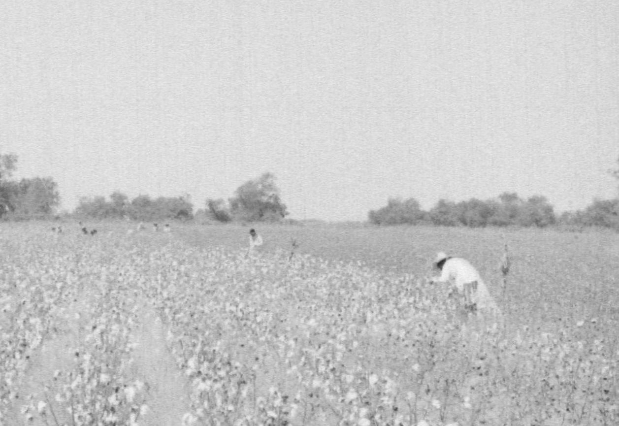
 Probably the same field during a harvest in the late 1950s.  (Note the laborers picking by hand.)
 
A magnification of the laborers.
 
Pickers dragged a large bag along the ground as they filled it with cotton.  Summer heat wasn't the only difficulty.  An adult (as you can see in the photo) had to bend over to reach the plants.  Eventually, tired backs forced pickers to work from a kneeling position.  They often wore knee pads to save wear and tear on overalls and sore knees.  

I guess children had an advantage in not having to bend over to reach the plants.  This photo shows students at a small school near Corsicana in 1913.  Each of them picked cotton before entering school that fall.  (Child labor was common in the cotton fields before mechanization.)
 
(Traces of Texas)

My friend up in the South Plains said picking cotton down here is different than it is up there.  Conditions up there meant hand-picking required pulling the burr from the plant.  (The burr is the dried shell from which the boll emerges.)  Down here the conditions (and maybe the hybrids we can grow) allowed pickers to pull the lint from the plant without taking the burr.  The lint still contained the seed, but it was far cleaner than cotton picked in north Texas.  This difference still applies to mechanical harvesting used today.

Of course, mechanized harvesting became common in the 1960s.  The next photo shows an early picker used in the same field south of old Sugar Land.  It looks like the machine is mounted on a tractor, although it's probably a permanent attachment.
 Rear view of an early mechanized cotton picker in field near Sugar Land.
  
  View of early mechanized cotton picker in field near Sugar Land.
 
Magnified view of early mechanized cotton picker in field near Sugar Land.
 
Technological advancements have continued to the present day. Click here to view a modern cotton picker.

Next time a short discussion of hauling cotton.

Tuesday, August 11, 2015

A Short Video on the History of Pearland


I found this 12-minute video on the history of our neighbor to the east, Pearland, Texas.  I learned a few things. Click the image below to view the video.


Wednesday, July 29, 2015

Cotton

I watched a 6-minute clip from The Texas Bucket list, recently, on the historic Burton Cotton Gin & Museum.  Click here to view the video.  This led to a discussion with some friends about cotton harvesting and ginning.

The Sugar Land Heritage Foundation archives has this undated photo of loaded cotton wagons lined up in 'downtown' Sugar Land waiting for a spot at the gin.  (The date of the photo is probably 1910, give or take a few years.)  


You can see the railroad tracks on the left side of the photo, so the camera is pointing west, down what is now Kempner St.  The wagons are parked about where the Farmer's Market is held today.  

Notice that the farmers have covered their wagons with tarps.  In my day, the wagons had sides made of chicken wire, and covers were optional.  During harvest time, there was probably enough cotton strewn along Brooks, Main, Kempner and Highway 90A to make a bale of cotton.

Here are some photos of the modern approach to harvesting cotton.  I took the first two a couple of years ago near the George Ranch Historical Park south of Richmond.


Obviously, a mobile unit came out to the field and formed those large blocks of clean, compressed cotton.  I didn't stop to get a closer look, so I thought maybe they were completely ginned, but a friend said that's not the case.  They are partially processed and still need further work at a gin.  He took the next photo of the same sort of blocks awaiting processing at a gin in Crosbyton, Texas just east of Lubbock.  Flat-bed trucks with tilting beds pick them up and haul them to the gin.
 
Photo by Bill Barksdale.
 
My friend said the gin was incredibly noisy, and that's the way I remember the old Sugar Land gin.  I went there once with my father when I was about 5-years old.  I was the kind of kid who didn't like loud noises, so I had my hands over my ears the whole time.

Wednesday, July 15, 2015

"NOC NA TANEÄŒKU"


I watched this 13-minute documentary about Czech dance halls a few days ago and enjoyed it.  (Seaton, Texas is a few miles east of Temple.)  Click here to view the video.

Tuesday, April 21, 2015

Interactive Map & Photos of the San Jacinto Battleground

Since it's April 21st, I thought I'd post this set of interactive map & photos of the San Jacinto Battleground.  One is a historic map drawn in 1856 by Henderson K. Yoakum, an early Texas historian.  It shows the battleground as it appeared at the time of the battle.  The second is an aerial taken in 1930.  The third is a contemporary ESRI satellite aerial.

Free Admission to Texas Historical Sites - May 3rd


I got a note recently from the Texas Historical Commission saying various Historical Sites will offer free admission on Saturday, May 3rd.  


If you live in the Sugar Land area, I saw three sites that are within easy distance.

Click here to details on the Levi Jordan Plantation home in Brazoria County.  It showcases local agricultural history and the African-American experience in Texas.

Click here to view details on San Felipe de Austin in Austin County.  Stephen F. Austin founded San Felipe de Austin as his colony's administrative capital.  A state park offering hiking, biking, camping, and canoeing is close by if you're interested in those activities, too.

Click here to view details on the Varner-Hogg Plantation in Brazoria County.  It is the site of a restored, stately plantation home once owned by the Hogg family.

Monday, October 6, 2014

Prison Farm News From the Late 1890s


I've come across three articles about the prison farm west of Sugar Land while researching old newspapers.  The first one comes from The Sunday Gazetteer published in Denison, Texas on Sunday, March 18, 1894.  

At this point in Texas history, the state employed a convict leasing system, in which convicts were leased to private businesses at a fixed daily rate to perform various types of labor. Some worked for railroads; others worked for manufacturers, but most worked as unskilled farm laborers.  The state operated conventional prisons in Huntsville and Rusk, but a large number of convicts were scattered across the state in private labor camps.

The heirs of Ambrose Littleberry Ellis and Edward H. Cunningham owned most of the land that now constitutes Sugar Land.  Both used convict labor in their operations.  This article gives you a snapshot of their involvement in convict leasing.  I recognize additional Fort Bend County landholders in the list: T. W. House and C. W. Riddick. Some of the others may have been Fort Bend County plantation owners, but I'm not sure.  You'll notice there were just under 4,000 prisoners in the state penal system.  Over half (2,158) were located in the prisons at Huntsville and Rusk.


The next article is rather long, a little odd, and only mildly interesting, except for the final 3 paragraphs which give a quick sketch of Sugar Land in 1896.  Like the other two articles I found, this one comes from The Portal To Texas History.  Click here to view the whole article which was published in the Fort Worth Gazette on Thursday, January 9, 1896.  It begins at the top of the third column, but since it's long, I'll summarize it for you.  

The State of Texas sued L. A. Whatley, Prison Superintendent, and Reddin Andrews, a prison sergeant, for $75.  The State claimed both men conspired to pay Andrews a month's wages for work time he didn't perform.  The article is unclear on how this came about, but the State claimed fraud and wanted it's money.

The newspaper explains that the trial was held in the depot at Sartartia (the old Walker Railroad Depot), which sat by the tracks roughly where the entrance to Central Unit 1 is now sited.  This makes sense because that's approximately where the alleged crime was committed.  The accused brought many friends and jammed them into that little building.  The State was represented by the County District Attorney, who wanted the trial delayed and moved to Richmond.  The defense team said no, but it sounds like they were overruled and the trial was moved.  (I haven't yet found a follow-up article, so I don't know how it all turned out.)

The proceedings were concluded pretty quickly, but it was close to lunch time, and there was no place for the famished crowd to find some nourishment.  I've clipped the final paragraphs that explain what they did.  W. O. Ellis was old Colonel Ellis's son, who would eventually die in a shoot out with a prison guard.  However, on that day he fed some peckish visitors.  Colonel Ed Cunningham was renowned for his hospitality, so the crowd that walked to Sugar Land was, no doubt, amply rewarded.  The Riddicks seem to have been equally generous hosts.  Sounds like none of the visitors left Sartartia that day with an empty stomach.


This final article comes from The Houston Daily Post, published on Monday, January 4, 1897.  Click here to view the complete version at The Portal To Texas History.  I've clipped just a couple of excerpts.  The first shows that Cunningham was by then the largest lessor of convict labor in the state.  The Ellis family doesn't appear in the list.  

If you look at the complete article, you'll see there are 'Contract' and 'Shared' Farms - Cunningham is listed under Contract Farms.  I'm not sure what the distinction is.


This excerpt gives a brief description of the Harlem Prison Farm and its financial performance.

Sunday, June 29, 2014

Construction of Highway 90A in 1927


I've collected photos of the construction of Highway 90A from several sources, but most of these I received from Terrell Smith.  (Thank you.)  

The Highway was paved in 1927 as a two-lane road.  Those of you who remember it was a four-land road will understand when I say it was the westbound (or northern) lanes that were first paved.  Bridges and other support structures were built before the paving was done.

Sugar Land was still isolated after the road was improved, but it wasn't quite as isolated as it was before.

The annotations say these were taken east of town between Sugar Land and Stafford.  I've taken a close look at the horizon in all the photos, and the annotations seem to be correct.


A Failed Attempt At Prison Farm Centralization in 1929


While researching old newspapers, I found this short, front-page article in the Breckenridge  (Tex.) Gazette published on November 6, 1929.  It mentions an effort (which eventually failed) to centralize, and modernize the Texas prison system.  As the article explains, there were three competing proposals, one of which nominated Sugar Land as the location for the new centralized prison.


An article at the Texas State Library and Archives explains what happened.  The Legislature passed a funding bill, which Governor Dan Moody refused to sign.  It provided enough funds to upgrade existing facilities, but not a penny to build a modern, centralized prison.  Click here to read the article.   (Click here to read more on that era of the Texas prison system's history.)

Central Units 1 & 2 were constructed as a result of the Legislature's 1930 appropriation for upgrades.  I'll have to research the exact dates, but I'm pretty certain they were built in 1930 & 1933.

Sunday, June 22, 2014

The Galveston - Bolivar Ferry


I received the photo below from a friend, but I'm not sure where he got it.  It's not dated, but someone has suggested the 1940s.  Could be, but I that's exactly the way I remember the ferry in the 1950s.
  
     
The ferry is the Cone Johnson, and we see it as it docks at Bolivar.  This Wikipedia article says the three original ferries were the Cone Johnson, the R. S. Sterling, and the E. H. Thornton, each a namesake of a Director of the Texas Department of Transportation.  (Of course, Sterling was also a governor.) 

Another article I've read said the State charged $.25 a car to travel on the ferry until 1949, when it became free of charge.

Saturday, March 1, 2014

Old Farms & Ranches In Texas

Sunday, January 26, 2014

More Images Of Old Sugar Land


We have many, many photos of the Char House over the years, and I've posted quite a few of them.  I decided to post this one because of its aesthetic quality.  It has a slightly dramatic quality to me, and it shows date palms along Highway 90A.  The date is sometime in the late 1920s.


A view of the north side of Highway 90A a the intersection with Main St.  The Salvage Buildings are on the right.  Note the sign indicating Sugar Land Mfg. Company is the occupant.  (I can't guess what they were manufacturing -- they were into all kinds of enterprises.)  The Sealy Mattress building (later Marshall Canning) is on the left.


The quality of this aerial photo is incredible -- very crisp and clear.  It was taken sometime between 1925 (when the Char House was completed) and 1942 (when the Humble service station was built at the intersection of Brooks and Highway 90A).  Note that Highway 90A is just 2 lanes.  The Imperial Inn is standing on the east bank of Oyster Creek south of the highway bridge.


I can tell by the automobiles that the next photo predates the previous one.  I can also tell it was taken before 1932 because the 2nd semi-circle of the school on Lakeview hasn't been built.

Its resolution is superb, but the contrast isn't good, so some areas are washed out.  Still, you get a good view of the west side of town.  The clinic hasn't been built on the corner of Ulrich and Sugar Land (now Kempner) St.  The Prikryl Hotel is the two-story wooden building in the middle left.  There is a steam engine on the siding next to the highway, and you get a view of the houses along the south side of Highway 90A.  They were later moved to South Belknap in Brookside.


These next photos came to me courtesy of Haroldetta Robertson.  Her father-in-law was the HL&P lineman who covered the Sugar Land area.  (I have a picture of him in the People of Sugar Land post immediately below.)  The HL&P substation appears in these photos.  (I'm working on the exact location so I can position it on a current Google map.)  It was located south of Highway 6 near the current location of First Colony Mall.  The Robertsons lived in a home adjacent to the substation.

These are Robertson family in-laws posing near the HL&P substation, which appears in the distance on the right.  This picture was taken in 1952.

This is Louis Robertson (DHS '62), Haroldetta's husband, as a 4-year old in 1948/49.  The substation is in the distance.

This is a photo of Louis standing in front of the modernized substation in 1997, almost 50 years after the previous photo.

When you visit the Sugar Land Museum, you'll see a super-sized poster of the first photo below, which shows convict labor handling sugar cane at the Imperial Mill located on the south bank of Oyster Creek behind today's Nalco-Champion complex.  The State of Texas owned the Mill (it sat on prison farm property), but the raw sugar it produced was refined at the Imperial refinery.  The mill was constructed in 1883 and burned in 1913.  The second photo shows convict labor harvesting sugar cane on the Harlem (now Jester) prison farm around 1900.


From Chain Gangs To Chain Stores


I've been corresponding with Patsy Sims, a writer who is researching the Central Units on the prison farm west of Sugar Land.  I've learned quite a bit from her already and hope to learn more.  As you'll read in the article below, her grandfather worked there until retirement in 1949, and Patsy has vivid memories of extended summer visits to her grandparent's home on Flanagan Road.

She wrote this article for the Texas Observer in 2007.  It includes fascinating photos and recollections of this vanishing part of our local history.
   

Monday, January 13, 2014

Catching Up On Old Items


When I recently posted a couple of items about Jerry Naill (DHS '64), I forgot to include a link to his Web site.  Jerry is still making music, so click the following link to hear his latest work.  (Thanks go to Mary Lee Brodecky Sebesta, one of Jerry's Dulles classmates.)


Frank Lampson (DHS '68) pointed out something special I didn't remember about May 5, 1961.  That was not only the date of the Dulles Band's Spring Concert, but it was the day NASA launched Alan Shepard into space and made him the USA's first extraterrestrial citizen.

Finally, Jon Pitts (DHS '61) noted something I said about this Imperial Crown article about the old Sugar Land Railroad.  I stated the author mistakenly referred to Highway 90A as Highway 59.  

Well, back in those days (before the freeway was extended across Fort Bend County), the segment of Highway 90A from Houston to Rosenberg was also designated as Highway 59.  I'd forgotten about this until Jon reminded me.   

A year or so ago, I wondered how we got to Victoria and other locations on Highway 59 before the freeway was created.  Then I remembered that 59 branched southward off 90A on the west side of Rosenberg where Highway 36 branched northward.  Thanks, Jon, for reminding me of this.
 

Sunday, January 5, 2014

More Images Of Old Sugar Land

 
This aerial photo of the Humble Camp south of Sugar Land was taken on February 28, 1941.  The vertical line through the middle is Oil Field Road.  The broad, dark, horizontal stripe in the lower third is the Brazos River levee.


The following 3 photos show Oyster Creek looking northward from Lake Pointe.  (Essentially, these are reverse views of the photos shown in an earlier post.)  The date is uncertain, but I think it's the late 1950s.


The following two photos aren't good, but I wanted to post them because they show the polling location for an election in June 1966.  The old voting spot for all of Sugar Land was always the hallway of the shopping center, which you see here.  You may be able to see the sign for the beauty parlor on the right wall.  Notice there are no voting machines -- you can barley see standup counters with privacy panels against the left-hand wall.


The following photos show an event nearly 16 years later, the unveiling of a state marker for the Imperial Refinery in March 1982.  Dignitaries include Harris Kempner, I. H. 'Denny' Kempner, III and W. R. Eldridge, son of W. T. Eldridge, Sr.


There are relatively few color photos of refinery operations, but the following is one I thought particularly good from an aesthetic point of view.  I don't have a date for it.  I think they are filling a liquid sugar rail car.  The camera is pointed eastward.  The Char House is out of view on the right.