Drop Down MenusCSS Drop Down MenuPure CSS Dropdown Menu
Showing posts with label Houston. Show all posts

Saturday, March 31, 2018

More Historical Photos of Houston, the US, and the World

Click this link to view color photos of Houston in the 1950s and '60s

These next photos come from a Rice history blog that I follow. Look at the 2nd aerial, which gives a good view of the empty space between Houston and Stafford.

My thanks to the readers who sent me the following photo album. There are a few repeaters, but most are new (to me).

Click the image to view it.
 
 Construction of the Empire State Building, 1931.

Tuesday, January 30, 2018

Video of Snow Storm on February 12, 1960

We had a surprise snow fall here in Sugar Land on December 8, 2017. Donna Christopher Baker (DHS '63) sent me this link to KTRK archival footage of the snow fall we had on Friday, February 12, 1960. I remember it well. I have posted items about this snow fall, and others, in earlier blog entries.


I'm happy to report that we've recently received digitized home movies of Sugar Land after the 1949 snow storm. We've also received digitized movies of the 1951 ice storm. Once we have edited these clips, I'll post them on the blog. They offer superb scenes of the town nearly 70 years ago.

Sunday, April 9, 2017

A Little More About The Dome

The rodeo ended last month, so I know I'm a day-late-and-a-dollar-short, but I wanted to post this series of photos which comes from a soft-cover book published in 1965 promoting the newly opened Astrodome. (My thanks to Frank Lampson for lending me the book.)

The final section was a look ahead at the 1966 Fat Stock Show and Rodeo, which appeared in the Dome for the first time. Johnny Harris (DHS '64) tells a hilarious story about 'helping' a performer get on his horse before riding through the big gate in center field to entertain the crowd. Let's just say Johnny thought the entertainer needed a seat belt on his saddle to make it through the performance!

Click the image below to view the photos.

Friday, March 10, 2017

Houston

I saw the following photo on Facebook and thought it was interesting due to the distant background. I think it shows an aerial view of the Astrodome area looking southwest in 1965. Loop 610 is under construction.  (The feeders are the double lanes across the upper third of the frame.) Kirby is the street next to the parking lot, and South Main angles off into the upper right side of the frame.

The pilot flying the helicopter, Frank Pasket, submitted it to the Facebook Page, Traces of Texas.

(Photo courtesy of Frank Pasket and Traces of Texas Facebook Page.)

Donna Christopher Baker sent me the following link to an article in The Houston Chronicle. It explains how many of Houston's suburbs got their names. Click the photo below to view the article.

Houston Suburbs
(Photo courtesy of The Houston Chroncle.)

Sunday, July 31, 2016

1919 African-American Flour Mill in Houston Texas

While reading issues of the Texas Commercial News (Sugar Land's local newspaper) published in 1919, I ran across this item in a June issue.  It mentioned a flour mill owned by African-Americans, which  opened in Independence Heights, Texas.

I had never heard of Independence Heights, much less "Flavo" and the American Milling Company.  I searched for more information, but found very little. Independence Heights was an incorporated community inhabited by minority citizens.  It was located an area north of today's 610 loop and west of I-45. The community chose to dissolve and be incorporated into Houston in the late 1920s. I guess the mill didn't have a long life because there is no record of it that I can find.

I've posted an image of the article, but I've included a transcript below if you don't want to strain your eyes.


Houston's First Flour Mill Began Operation Monday

The only flour mill in the vicinity of Houston, owned and operated by negro citizens of Independence Heights, started production Monday afternoon, following formal opening exercises. The mill is owned by the American Milling Company, of which H. J. Ford is president.
A large crowd of negro citizens gathered for the exercises and were given samples of the "Flavo" flour that the mill will put on the market.  O. L. Hubbard, mayor of Independence Heights, made an address of welcome, expressing the pleasure of the community at having the mill opened in the vicinity.  Its opening is evidence of the industrial progress of the colored race, he said. 
H. J. Ford responded on the part of the milling company, and other Negroes made short talks.
The Flour produced at the mill will be sold direct to the consumer for the present.  It will be of the very highest grade, but will retail at prices usually charged for the medium grade flour in Houston, it was announced.  It will be put up in 12, 24, and 1 pound bags, but also will be sold in four, six, and ten pound packages.  As soon as possible, every negro grocery store will be supplied with the flour.
At the present time the mill has a capacity of 15 barrels of flour a day and 10 barrels of meal.
A number of white citizens visited the mill Monday, including several millers from neighboring towns.

Miscellaneous

Here are some odds & ends I found since my last posting.  The first is a video clip from a 1956 episode of the old I've Got A Secret game show.  I think it's amazing.  I've read that the man died just a couple of months after appearing on the show.


A fellow named Jim Lange posted this photo of Foley's department store his father took in 1938.  This store preceded the one most of us remember, which was built in 1947 on the corner of Main and Lamar.  This store was 400 Main Street several blocks north of Main and Lamar.

Foley's at 400 Main in 1938.

Thursday, May 5, 2016

Miscellany


My brother Bruce found a reference to the 'weather eye' that sat at atop the Texas National Bank Building in downtown Houston.  I assume the building had a Main St. address, but it was located next to the First Methodist Church.  Info says the weather eye began operation in 1957.  I found two photos to refresh your memories.


The weather eye (ball at the top of the sign) provided a simple, highly visible forecast of Houston's weather, as explained in the lyrics of an ad the bank ran on local radio stations:
Red light warmer weather
Blue light cooler weather
Green light no change in view
Blinking light, rain is due.

I may be dreaming, but I think they may have run a television ad with the same jingle.  Regardless, I remember seeing it when we drove up Main St. to shop at Foleys.

I found the following map showing the empresario land grants authorized by the Mexican government when Texas was still part of Mexico.  We tend to focus on Austin's colony, but you'll see that many other empresarios colonized Texas.  Click on the image to view other maps.


I want to thank my aunt (Mayme Rachuig Hause) for sending a link to this short film from the 1920s, entitled "Oil Field Dodge." It shows a Dodge automobile plowing through rough terrain to reach an drilling site out in the boondocks.  

Of course, the purpose of the film was to show the robust nature of Dodge vehicles, but it's important to note that roads were pretty bad back in the 1920s.  Prior to 1927 when it was paved and renamed Highway 90A, the road from Houston to Rosenberg and points west could become so muddy that teams of mules were needed to get cars out of boggy areas.

Tuesday, March 29, 2016

Miscellany


This first item is roughly a month late, and the image quality isn't as good as I'd like it to be, but I saw this map on Facebook and thought it was informative.  It shows the Alamo as it looked in February 1836 with an overlay of modern streets.

As you can see, the Alamo was much larger than we imagine.  I think the State of Texas has acquired the land on the west side of the plaza where Ripley's is located.  I think their intention is to eventually reconfigure the plaza so it's closer to its layout in 1836.

I recently read Blood of Heroes by James Donovan and finally understood that the main entrance to the Alamo complex was on the south side, where Jim Bowie's room is noted on the map.  The other thing I didn't realize is that the main part of the battle did not occur at the west wall.  The north wall and east wall were the site of the most intense attacks on the final day.  An attack from the south and a late surge at the west wall occurred at the very end.
   
 
A fellow who posts photos on Facebook under the name Traces of Texas posted the following, which show Rollover Pass in 1957.  (The pass is on Boliver Peninsula several miles east of the ferry landing.)  

I never realized that Rollover Pass got its name from smuggling.  The pass was a strip of land where the peninsula was at its narrowest.  Smugglers would land their boats in the surf and then roll barrels over the narrow spot and reload other boats with their contraband and haul it into Galveston Bay for distribution at various rendezvous.  Smugglers skirted customs at the Port of Galveston which patrolled the mouth of the bay between Galveston and Boliver.

Apparently, the pass was dredged on private land in 1955.  By 1957 it was a hot spot for fishing, as these photos attest.  Actually, it's still a good fishing spot, judging by the photos I see on Facebook.
 
Rollover Pass in 1957.

Rollover Pass in 1957.
Some of you may have read recently, that Schlumberger is moving its US headquarters out of Houston to Sugar Land.  I found this article in the September 1956 issue of The Imperial Crown, announcing Schlumberger's purchase of 1,300 acres of land in what eventually became Sugar Land's industrial park north of Highway 90A.

I had forgotten Schlumberger came to Sugar Land that long ago.
 
I could have sworn I saw Milkdrop Moe on Houston television when I was a child, but based on what I've found on the Internet, he was gone before I could turn on a tv set.  Here's what Earl Blair posted on Facebook:
  
Milkdrop Moe with Uncle Ned.
  
THE MYSTERY OF THE MISSING MILK DROP - I've been watching Houston television, off and on, since 1951. In those distant days, KPRC-TV was the only station telecasting blurry, black and white images to the rabbit ears perched precariously atop our 14" family Philco.

My very favorite Houston television personality from that time, was a large, talking milk drop -- yes, talking milk drop -- named "Milkdrop Moe."

Along with his human counterpart, Uncle Ned, Milkdrop's fifteen minute daily show basically served to introduce Crusader Rabbit animated cartoons and sell Sanitary Farm Dairies' milk. What could possibly provide a better endorsement of milk to a six year-old mind like mine, than first-hand testimony from a milk drop?? And one that peppered his salesmanship with a bounty of bon mots, to boot.

Noteworthy is fact that Crusader Rabbit was the very first animated cartoon series from Jay Ward, then partnered with the show's creator Alex Anderson, who later delighted television viewers with Rocky, Bullwinkle, George of the Jungle and dozens of other memorable animated cartoon characters. It was also the first cartoon series designed specifically for television. The initial episode—"Crusader vs. the State of Texas"—aired on KNBH (now KNBC) in Los Angeles on August 1, 1949.

Inside the cramped costume was talented comedian, Bobby Lauher (sometimes spelled Larr professionally). Lauher (1930-73) was born in Illinois, but grew up in Houston. A popular personality on KPRC-TV, he also teamed with Johnny Royal for that station's local comedy show, "The Guys Next Door." He found greater fame as part of Ernie Ernie Kovacs' ensemble and as a comedy writer providing laughs for Rowan and Martin and many others.

As memorable as Milkdrop remains in my mind, the show was only on the air for two years, 1952-53, and was a local Houston creation, which made finding memorabilia difficult. I located images of a badge and personal appearance flyer, but a photo of the pasteurized personality had proven elusive for decades.

That is, until this morning when, in one of my endless Internet searches, happened, purely by chance, to come across the below photo. Here, then, for all of you old enough to remember, is Milkdrop Moe and his pal, Uncle Ned. (See photo above.)

Monday, January 25, 2016

Miscellany


I found the following image of Curly Fox and Texas Ruby with their band at KPRC's television studio in the 1950s.  It was posted to the KPRC History page on Facebook, which is well worth a look if you're interested in the history of Houston television.  Obviously, Texas Ruby is the woman standing on the left.  Curly Fox is in the man standing on the far right.

  
My good friend and DHS classmate, Frank Lampson gave me a card on my recent birthday.  (It was my 66th BTW.)  It included a booklet with interesting facts about that important year.
  
(Click on the image to view album.)
 

Monday, August 24, 2015

Miscellany


Galveston Ferry (Boliver landing) in 1963.
(Mark Maniha - Traces of Texas)
 
Earliest known photo of Houston - 300 block of Main Street in 1856.
(Traces of Texas)
   
Oscar Holcombe campaign poster, 1921.
(Story Sloane Gallery)
  
The Houston Chronicle ran this album of color photos of Houston taken by Cecil Burdick, Jr. in the 1950s and '60s.  Click this link to access the article and slide show.

The Texas Historical Commission has produced another mobile app tour: the La Salle Odyssey.   
 
 
Click here to access the tour on your personal computer.  Note this link under the large graphic: Watch - The La Salle Odyssey.  Click it for a good overview of the La Salle expedition.
 
You can download the mobile app for use on your mobile device at iTunes (Apple version) or Google Play (Android version).

Wednesday, August 12, 2015

Story Sloane Gallery in Houston


Story Sloane, III owns a gallery devoted to historic images of Houston and the surrounding area.  In fact, he's devoted to preserving endangered visual artifacts, including restoring damaged images and researching/identifying unknown subjects.  He has a fantastic collection.  I've bought prints of his historic photos and given them as gifts.

He's posted a couple of photos I thought worth reposting here.  The first is an undated aerial photo of the Gulf Freeway above roughly where U of H is located.  My best guess is it was taken in the late 1940s or early '50s.


You can see Buff Stadium near the center.

Click here to view some of Story's vintage oil industry photos.

The next photo is an undated aerial showing Hermann Park and the area around it. I've read that the Houston Zoo opened in 1922, but I think it was rather 'undeveloped' in its early years.  I think they built enclosures and structures in the 1930s.  If that's the Zoo under construction near the upper-right corner, the photo was taken in the '30s.

You can see Rice University (then Institute) and Hermann Hospital in the upper-left corner.  The area at the bottom is South MacGregor Way and Brays Bayou.  Large houses (under construction) are in the foreground.


I can't recall where I got the next photo, but the file name indicates it came off Facebook.  (Wish I could give proper credit to the poster.)  It shows Houston Municipal Airport in 1933.  Of course, Hobby Airport would be built several decades later in the open space beyond the runways.

Tuesday, May 26, 2015

Salt Grass Trail Ride Stops in Sugar Land in 1954


The Sugar Land Heritage Foundation's photo collection contains these photos of a group of Houston rodeo trail riders in late winter of 1954.  I did a little research, and I understand that in those early years the Salt Grass Trail Ride consisted of subgroups which would collect at a point west of Houston and ride into Memorial Park as a group - i.e., the Salt Grass Trail Riders.

The chuck wagon's sign says they are from the CU Ranch in Sugar Land.  I haven't found any info on the CU Ranch, so if anyone knows anything about it or the riders, I'd appreciate any leads.

This first images is an aerial showing Sugar Land in 1956, just a couple of years later, but it's useful in orienting you where the trail riders were when the photos were taken.


The trail riders near the Sugar Land Motor Company.


The trail riders in the big field behind the shopping center, not far from where today's post office is located on Matlage Way.


Saturday, April 18, 2015

Houston, Then and Now


The Astrodome has been in the news lately, at least The Houston Chronicle, so I've seen several historic photos of that well-known structure.  The aerial below was one of the best.  It appeared on the Traces of Texas Web site.  You get a good view of how things looked around Reliant Stadium back in the mid 1960s.

Kirby Drive is in the lower left.  Old Colt Stadium is in the middle left.  The Medical Center (along Main and Fannin Streets) is further in the background on the left.  If your eyesight is good, you can see the Warwick Hotel (now Hotel Zaza) further down Main St. towards the middle.  Downtown Houston is on the horizon beyond it.  

I think the large white complex in the middle distance behind the Dome at roughly 1 o'clock  is the old Veterans Hospital on Holcombe Blvd.


My classmate, Marsha Bauman Shaw (DHS '68) took the next two photos of trail riders as they rode near her home in Memorial in February.  Of course, they were on their way to camp at Memorial Park.  I found some photos of Salt Grass Trail riders camping in Sugar Land in 1954.  I'll post them next week.


Thursday, April 9, 2015

Photos of Rice Institute (University) in 1931 & 1950


I saw the following aerial photos on Melissa Kean's blog about the history of Rice University.  (Melissa is Rice's resident historian.)  The first was taken in 1931 and shows West University before it was developed.  I've added annotations to help with orientation.


This next photo was taken 19-years later (winter of 1950), when Brown & Root built today's Rice Stadium in 9 months.  It opened in time for Rice's first home game of the season against Santa Clara in late September.


The area around the campus has started to look more like it does today, although the block along Greenbriar is fairly empty.  Christ The King Lutheran Church is now in that spot.

Wednesday, February 11, 2015

Photos of old Houston

 
I want to thank Jerry Cooper (SLHS '56) for sending me a link to these photos.  Great stuff. 

Click on the image below to view the album.  I've borrowed captions from Tana's site, but added my own comments in parentheses.


If you're intrigued by the old photo of Marvin Zindler as a newsman, I've posted some of his early radio programs. Click here to listen to some.  They're a hoot.

Wednesday, October 29, 2014

Odds & Ends

 
Notice the home games were split between Sugar Land & Missouri City during Dulles High's first season.

Scotty & Dot Hightower gave me the next two images.  At first we weren't sure they showed Kempner Field, but now I'm fairly certain they do.  I think they show it before the 1958 reconfiguration with the cement stands on the west side of the field and the lighted scoreboard behind the south end zone.

I think that's Butch Boyd throwing the shot next to the old visitors' stands on the west side of the field.  Note the old scoreboard in the distance on the left.

The second shows Coach Hightower with some of the track team on the south side of the field.  Note the concession stand and ticket booth in the background.  If I remember correctly, that was the main entrance into the field.


I've included this final photo showing the corner of Milam & Prairie in Houston in 1945.  (It was posted on Facebook.)


Tuesday, October 28, 2014

Story Sloane, III


I wanted to commend a fellow, who does a lot to preserve Houston photographic history, Story Sloane, III.  I met him a couple of years ago at a history book fair in The Heights.

Story has a shop in west Houston where he sells prints of old photos.  I've bought 4 prints of the dairy at Sartartia and gave them as Christmas gifts last year.  He has a few photos relating to Sugar Land, but the vast bulk of his archive is devoted to Houston.

Click this link to view a 4-minute clip that appeared on Channel 8 in 2010.  Unfortunately, the aspect ratio isn't correct in places, but it's still worth watching.


If you're interested in collecting old photos with local relevance, you should drop by his store at 1570 South Dairy Ashford, Suite 113.  

Story Sloane, Mike Vance (Houston Arts & Media), and John Gonzalez (Bayou City History in The Houston Chronicle) are highly commendable  preservationists of local history.

Saturday, September 27, 2014

Rice whips Santa Clara 27 - 7 in New Rice Stadium on Sept 30, 1950


Nearly 64 years ago to the day Rice University (then Institute) played its first game in Rice Stadium.  The Owls defeated Santa Clara 27 - 7.  Click this link to read a brief account of the game.

It was Rice's homecoming game, and since it was a special occasion they had a celebratory parade down Main St.  Click this link to view a few photosClick this link to read a special edition of The Thresher, Rice's student newspaper, which gives more details on the big event.  Notice page 4 has a short article about A&M's new Memorial Student Center, which had opened, but was not quite finished.  Also notice the abundance of cigarette ads.

Sunday, July 13, 2014

Odds & Ends


I came across these miscellaneous items as I researched old newspapers.  I thought they were interesting.

I've seen several articles about Sugarland Industries traveling to various parts of Texas to recruit labor.  (A little known fact is the Industries sent an emissary to Germany to recruit workers there.  More on that later.)  This article appeared in the Brownwood Bulletin, issued on August 13, 1919.

  
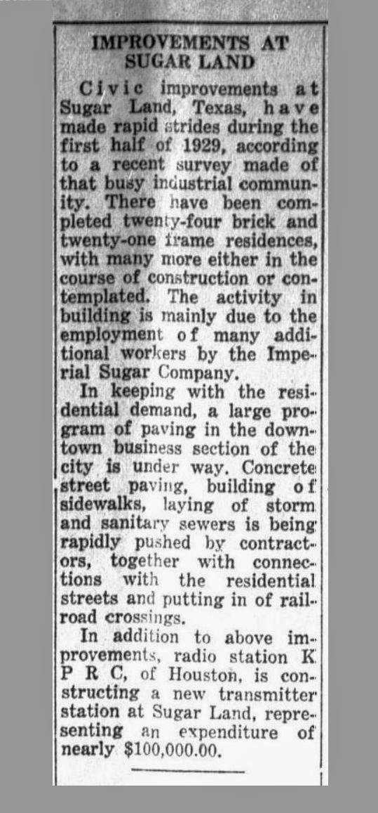
The next article appeared in The Naples (Texas) Monitor, issued on August 9, 1929.  The item I noticed appears at the bottom.  It says KPRC was constructing its transmitting station in Sugar Land.  (It was located near the intersection of Highway 90A and Eldridge Road - on the northeast corner.)

A few months later the Stock Market crashed and the Depression began.  KPRC relocated its transmitting station to La Porte about a year later.  I assume it was due to costs.


The Palestine Daily Herald printed the next article on September 1, 1908.   I know from the date that Kempner and Eldridge had just sold Sartartia (the Ellis Plantation) to the State of Texas, which would turn it into the Imperial Prison Farm, later Central Units 1 & 2.  This article mentions other units which were growing sugar cane and suggests the State was launching into the sugar business in a big way.
 
    
Last but not least, always beware of scam artists.
  

Houston's West End Park


Yesterday (Saturday, July 12th) the Harris County Historical Commission unveiled a marker commemorating Houston's old West End Park. Click here to view a Wikipedia article on the Park.  The map in the article is poor, so here's an annotated Google map to help you locate the Park in today's Houston.


You may wonder if Sugar Land has a connection with West End Park.  Well, it does.  No doubt many Sugar Land sports fans saw athletic competitions of all types there roughly 100 years ago, and I know with certainty that the Sugar Land Blues played a game at that site in 1915.  (I don't doubt they played there several times.)

A few years ago, Ultimate Fort Bend, a suburban section of The Houston Chronicle, had a story about the Blues playing Liberty at West End Park.  They've taken down the original article, but here's the text, which I saved for future reference.

Baseball in Sugar Land - Sound Familiar?

As the city of Sugar Land pursues a minor league baseball stadium and team, it's interesting to take a look back and see that baseball had a strong following in 1915.

Chances are you've never heard of Fletcher "Sled" Allen, but 95 years ago, he had many people in Sugar Land ticked off.  Allen was a baseball player who played one season with the St. Louis Browns in 1910 before he ended up being a player/coach in the Texas League.

In the summer of 1915, Allen ended up umpiring a baseball game at West End park in Houston between teams from Liberty and Sugar Land (which was spelled "Sugarland" back then in newspaper accounts).  According to a small story in the Rosenberg News-Herald, more than 1,500 people were in attendance for the game, which Liberty won, 1-0.  Unfortunately, there's no details on whether the teams were amateurs, semi-pro or perhaps rival schools.

Nonetheless, it was Allen's umpiring that drew the wrath of many in attendance. Here's what the news article had to say:

"A crowd of more than 1500 people saw the Sugarland boys go down in defeat, and a great per cent of the crowd also realized that Sugarland's defeat was due almost entirely to the partial umpiring of "Sled" Allen."