Drop Down MenusCSS Drop Down MenuPure CSS Dropdown Menu
Showing posts with label Fort Bend County. Show all posts

Thursday, August 31, 2017

Harvey News & Updates

I haven't left the house since Saturday, and even then it was a half-mile trip to the Sugar Land Heritage Foundation to make certain everything was okay. 

My best guess is that old Sugar Land is almost back to normal. 

Emergency Contact Info

Here is some useful information from Mary Lee Sebesta and Wanda Benge. (Thanks!) 

FEMA
Thank you Kathy Stewart Ezell who works for FEMA for all this valuable information!!

Homeowners.... You must go through your insurance company first.....FEMA comes in behind your insurance for further possible assistance... You must register 1800-621-3362.

If you lost income because you can't go to work... Call FEMA 1800-621-3362 and register for disaster
unemployment.

If your vehicle flooded out in the storm.... You'll need to have liability coverage on your vehicle at the time of the disaster, your title & registration for FEMA (1800-621-3362)to pay. 

If you have full coverage you must file with your insurance company first.

If you're under mandatory evacuation... Call FEMA and register... You will get up to 2 months of rental assistance at the fair market value of your area.

If you have bills you are behind in or if you have some coming due you can call them EVERY COMPANY is pushing back due dates & some are even credited full months of service if youre in Houston or surrounding areas. My friend just got 3 months no car note w/toyota due to weather & another friend who has chevy got car note credited for 2 months! Call your light companies , phone companies ,cable companies whoever and get the extra months to give yourself time to come back from this disaster!! If you don't need this info then disregard but share. Never know who this can help.. All you have to tell them is you are located in Houston or surrounding counties and was affected by the hurricane... A lot of them are already aware of whats going on here and have policies in effect to help us.
There is a free app to help neighborhoods coordinate their recovery. It's called Next Door. Click here to find it on iTunes. Click here to find it at Google Play.

Sugar Land

Here is a link to the City of Sugar Land's page on storm info. Click this link to access the page

Here is a short clip of drone video Tommy Laird sent me. (Thanks, Tommy.) It shows Sugar Mill on August 27th, which now seems like a long time ago. I was a little confused when I first saw this, but I can tell it was shot on the western side of Sugar Mill. At one point you can see the pool near Burney and Ragus Lake Dr. 

Click this link to view the video. The map below will help you identify the area.

 
Fort Bend County & Brazos River

The major issue now is the Brazos River.  Here's a link to a the National Weather Service station at Richmond, which reports on the river's height. Click here to view the link.  As you can see the river should crest tomorrow.

Here is a link to drone footage shot by the Fort Bend County Office of Emergency Management.  Unfortunately, a lot of it looks exactly like last year's flood.  Click here to view the list of videos.

Fire Ants

And last but not least, an interesting video on Fire Ants. Click here to view the short video.

Friday, August 4, 2017

More People of Old Sugar Land

I've stretched the topic a little, but for good reasons. Click the image below to view the photo album. Be sure to turn on the captions option.


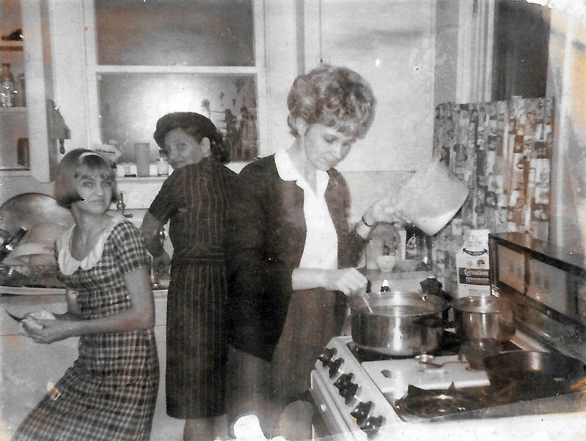
The Schumann kitchen on 6th St. back in the early 1970s.
  
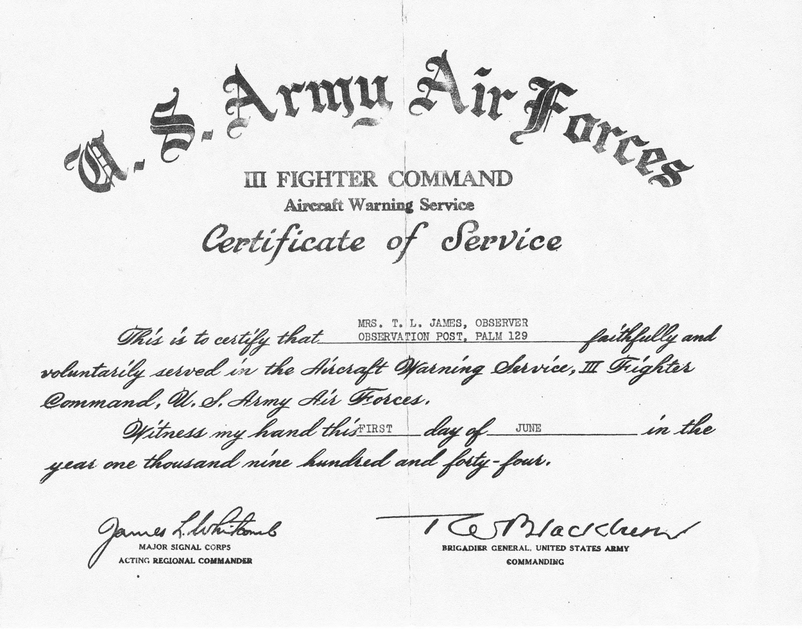
I've posted items on the aircraft observation group in Sugar Land during WWII. Jackie James has kept her mother's certificate of appreciation for serving in the group. You can see it below.

I've talked to my mother about this. They had a similar group out at the Humble Camp. She said kids were allowed in the group, and when they were on watch they reported almost everything that flew in the air. She said the operator at the other end was always respectful and polite. He or she never told them to cut out the useless chatter. Who knows if they ever wrote down what  children called in, but they made them feel they were part of the war effort.
 

Certificate awarded to Miriam James for service in Sugar Land's aircraft observation group during WWII.
   
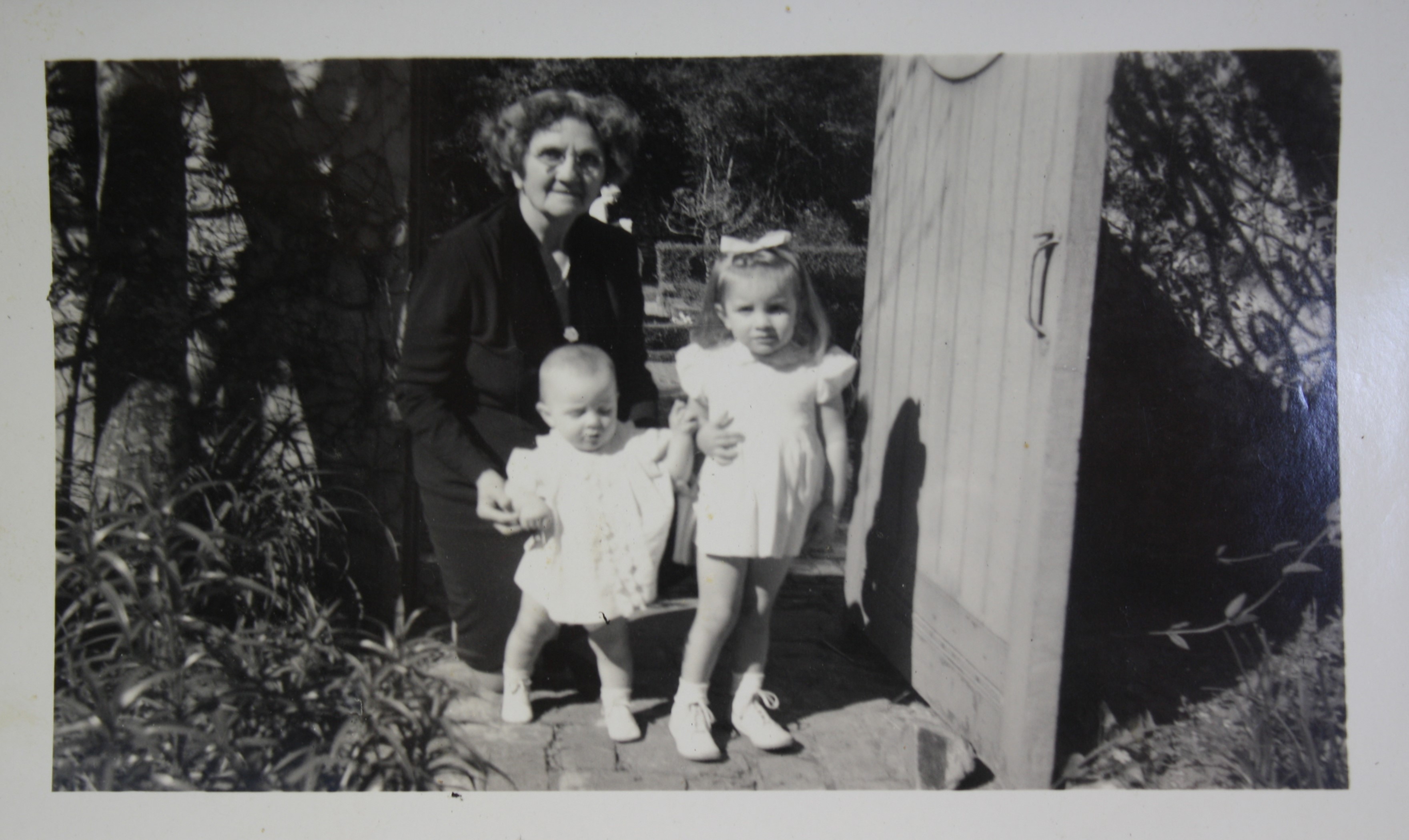
The final item was a surprise. I never knew former council woman, Cyril Hosley's family was connected to the Hoggs and Bayou Bend. Fascinating. Click the image below to read an article on her grandmother's employment with Ima Hogg at Bayou Bend.

Cyril Hosley on the right with her sister Carol and grandmother, Velma Arisman Beasley at Bayou Bend in 1949.

Brazos River & Fort Bend County History

About a month ago, I talked with John Rich, a member of the Harris County Archeological Society about water management on the lower Brazos River. We were looking through an Arcadia book Sharon Wallingford brought to my attention: Lower Brazos River Canals by Lora-Marie Bernard. 

John told me about a series of locks and dams on the river near Navasota. I had no idea there were ever any locks on the Brazos, but John said he discovered them on a canoeing trip he took in 2011 and documented in this article, which includes photos. Great stuff. Click here to read about John's trip.

A colleague on the Fort Bend County Historical Commission, Chris Godbold, writes a regular column on local history for Fort Bend Life Styles and Homes.  Here is a sampling.

Click here to view an article on Fort Bend County during WWI. (We are now in the 100th anniversary of The Great War.)


One final item: my brother found these photos of the Fort Bend County Courthouse by noted photographer Yarnell Richtie. (I wonder who those kids are.)

Fort Bend County Courthouse in 1948 by Yarnell Ritchie. (DeGolyer Library, Southern Methodist University)

Fort Bend County Courthouse in 1948 by Yarnell Ritchie. (DeGolyer Library, Southern Methodist University)

Thursday, June 22, 2017

Randolph Foster & Richmond Chapter of the SRT

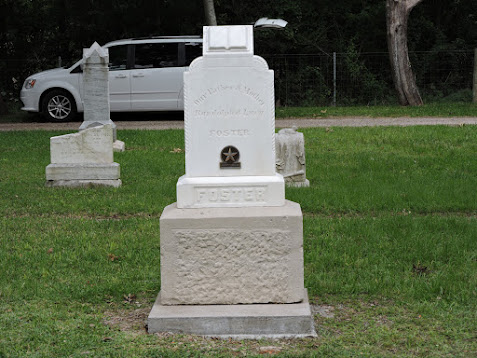
I want to thank Tom Green, KSJ Sons of the Republic of Texas, for sending me the article below on Randolph Foster, one of the Old 300. The Foster Family and Old Foster Community Museum hosted a dedication of an Old 300 grave medallion on Randolph Foster headstone in the Fulshear Cemetery. Click on the image below to view photos of the ceremony. (The relevant photos are #2 to #11 in the photo album.)
  
Randolph Foster Grave Medallion ceremony.

Tom participated in the ceremony and became interested in Randolph's story, so he did some research and wrote this short, but informative article.

History of Randolph Foster

ONE OF STEPHEN F. AUSTIN’S OLD 300


Randolph Foster was born March 12, 1790, in the Natchez District of Spanish West Florida, later known as part of the state of Mississippi. He served with his long time Texas neighbor, Capt. Randal Jones in the War of 1812, probably in the Canoe Fight on the Alabama River. In 1821, when he heard about Moses Austin’s plan to bring 300 American families to Texas, and Randolph Foster came to Texas with his parents, John Foster and Rachel Gibson, and their other children, including his brother Isaac Foster, making the Foster family one first of the Old 300. On July 16, 1824, Randolph Foster received a 4,400 acres land grant in what is now Fort Bend and Waller counties. Randolph Foster had married Lucy Ruffin Hunter, born on 23 June 1804, in Wilkinson County, Mississippi before 1821, and before the family came to Texas. Randolph Foster was a great hunter and stories exist about his hunts with Stephen F. Austin, and during the Texas Revolution, Uncle Ran, as he was known, provided meat and other supplies to the Texian Army.

On October 11, 1835, Randolph Foster was sent by Richardson R. Royall to William Stafford’s plantation, for whom the present town of Stafford was named, to retrieve 800 pounds of lead for the use of the Texian Army. In April of 1836, when Capt. Wiley Martin’s company was sent to the Fort Bend area to prevent General Santa Anna’s Mexican Army from crossing the flooded Brazos River, Randolph Foster joined Capt. Wiley Martin’s company, which consisted of only 46 men. There were at least 1,500 in Mexican Army, and the task of preventing the crossing of the Brazos River was impossible, but the delay was enough time to allow the newly formed Republic of Texas government to leave Jane Harris’ home in Harrisburg before General Santa Anna arrived. The delay in crossing the Brazos River resulted in General Santa taking 750 of his Calvary to Thompson’s Ferry to cross the Brazos River. The leader of Mexican Calvary was Col. Juan N. Almonte, who was one of the few Mexicans who spoke English, so the other Mexican Calvary hid in the trees, while Col. Almonte impersonated a Texan and convinced the Thompson ferry operator to bring the ferry over the Brazos River, where the Mexican Calvary came out of the trees, commandeered the Thompson Ferry and crossed the Brazos River flanking Capt. Wiley Martin’s Company and forcing them to retreat. This was the event that separated General Santa Anna from the bulk of his army, and when General Sam Houston learned of the separation he turn his army south at New Kentucky and head for Harrisburg, and later to San Jacinto. While the efforts of Capt. Wiley Martin’s men at the Brazos River was considered a failure at the time, this event changed history and was the main reason the Battle of San Jacinto occurred at the battle site.

Randolph Foster helped guide and protect the women and children during the Run-Away-Scrape. He continued to live in the Fulshear area until August 18, 1878, when the 89 year old pioneer died at the home of his daughter, Mary L. Foster, who had married Thomas Blakely, the Sheriff of Fort Bend County. A local school has been named the John and Randolph Foster High School, and on May 18, 2017, the family, who are almost all members of the Old 300 Society, dedicated an Old 300 marker for his grave.

Tom Green, KSJ
2718 North Larkspur Circle
Pearland, Texas 77584
(713) 340-1965

I wanted to mention the Sons of the Republic of Texas are reviving their chapter in Richmond. It has been dormant for a few years, and they want to restart it. If you can trace your ancestry back to the Republic of Texas, you can become a member. 

They are hosting an initial meeting at Joseph's in Richmond on July 20th at 6:30. Everyone with an interest and an ancestor in Texas between 1821 & 1845 is welcome.

Of course, the Daughters of the Republic of Texas have a proud organization, too. Their Richmond chapter is very active. If you have an interest in their organization, comment on this blog and I'll send you info.

Friday, March 10, 2017

Sugar Land Tenant Farms

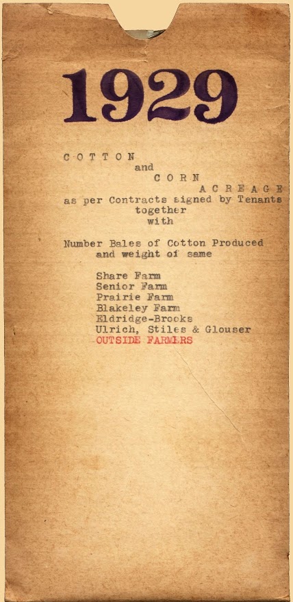
Several months ago I had a wonderful visit with Mr. Tom B. McDade (SLHS Class of 1940). We talked about a wide range of topics, but among other things he donated a collection of Sugarland Industries tenant farm records from 1929 to 1942 to the Sugar Land Heritage Foundation. His father was the clerk/bookkeeper for the Industries tenant farm operations and had saved these records long after he retired. Tom found them and wanted to give them to the SLHF.

These records are unique historical evidence of a forgotten part of old Sugar Land, but I haven't had enough time to give them proper attention.  I still haven't looked at them closely, but I wanted to post a brief selection now.  I chose the packet of records for 1929.

Here are some quick, summary points about what they contain:

1) The records cover cotton and corn crops, but cotton predominates by a large margin.

2) The Sugarland Industries Gin processed cotton from outside sources, as well as Industries farmers.  You'll see a separate list for these outside customers, showing the farmer and the farm owner, plus number of bales and total pounds.

3) You'll see lists for Share Farm (I assume these are Industries farms), Senior Farm, Prairie Farm, and Blakeley Farm. I'm not sure of the precise location of these farms (although I can make good guesses), or who actually owned them. I think the Industries probably owned the Prairie and Blakeley Farms, but I'll have to confirm that.

4) There are no dollar values, so I can't tell how much money was made on the crops. I'll try to find a cotton price for 1929 and make some rough calculations.

5) I assume some of these farmers worked part time at other jobs.  (Tenant farming may not have been their sole source of income.) Furthermore, I'm not sure about their contract with the Industries. I assume that in some cases the Industries supplied mules, seed, and other equipment and materials, which would mean some of these farmers were actually share croppers (using technical definitions of these occupations).

These records need a lot more analysis to uncover exactly what they tell us. Thank you, Mr. McDade for this interesting evidence from a little-know aspect of old Sugar Land.

Click the image below to view the records.
       

Fort Bend County

I want to plug Fort Bend County for a moment. I am chairman of the Fort Bend County Historical Commission, and over the past 3 years I have become aware of the myriad things our county does to preserve local history.

The first thing to highlight is the archeological work our Cemetery Committee does. The committee has more than 25 members who do all sorts of things to preserve the county's subterranean historical assets. The recent issue of The Medallion (from the Texas Historical Commission) included an article titled Super Stewards

Look closely at the accompanying photo and you'll see two of our Cemetery Committee members, Bob Crosser and Bruce Grethen. Bryan McAuley (also in the photo) is a Fort Bend County Historical Commissioner, as well as site manager at San Felipe de Austin. Sandy Rogers and John Rich (also appearing in the photo) are good friends of the Fort Bend Historical Commission even though they aren't members.

The article explains the thoroughly professional work these volunteers perform to preserve local history.

Click the photo to view the article.
 
Houston Suburbs
Super Stewards at San Felipe de Austin. (Photo courtesy of The Medallion.)

Some of you may be aware that the County is planning to restore the old Missouri City Gym. The historical commission is assisting the county government with this project.

Click the photo below to read an article about this renovation project.
  
Missouri City Gym
Missouri City Gym in 1937. (Photo courtesy of Lee Elkins LeGrand.)

The historical commission's Historic Preservation Committee has launch an ambitious, long-term project to survey the historic structures across Fort Bend County. The last survey was performed in 1980, well before the 'computer age,' so the end result will be an electronic version of the data collected.

The project began just a few months ago, but data collection is well underway. Here is an example collected by Bradley Stavinoha. It's the Horak Gin in Needville. (See the photos below.) 

I won't go in to a lot of detail, but here's what Bradley sent me in a brief email message:

"Original building constructed after WWI.  Victor Horak original owner. The 1929 Hurricane destroyed the building.  It was rebuilt and remodeled as ginning technology has changed through the years.

Ignac Horak operated it after Victor. Then Rodney Horak and now the brothers Kevin and Dustin Horak operate the gin.  Continuous operation at same location with same family for over 98 years.  One of the oldest in Fort Bend County."
(I'll bet most of you didn't realize there was a cotton gin still operating in Fort Bend County.)
 
Undated photo.


My cousin, Becky Bass Gallimore, sent me this article she found in a 1940 issue of The Rosenberg Herald. It is an announcement that the Sartartia Plantation (located in today's New Territories subdivision) planned to open a milk depot in Rosenberg. I assume this was a storage facility for home delivery of dairy products in Rosenberg and the surrounding area. It may have included a shop and ice cream parlor. (They operated retail stores in other location.)


One last item: The Fort Bend Museum is showing an exhibit of historic local maps through June. If you're a map fanatic (like I am), you might give it a try.  The article below is not directly related to the exhibit, but it explains the 'tools of the trade' in early map-making. Click the image to read the magazine article.
  
Early Surveying Equipment
(Photo courtesy of Fort Bend Life Style and Homes.)

Monday, January 2, 2017

News & Updates

I was swamped with other duties over the last two months, so items have piled up. I'll eventually get to them, but for now I want to mention just a couple of items. First, Mark Voss (DHS '71) died suddenly last week. Click here to view an obituary. I had no idea he had worked in Afghanistan. I have recent photos of Mark in the More People of Old Sugar Land posting immediately below.


Mark Voss.

My classmate (DHS '68) and good friend, Sam McJunkin, lost his wife Hilda suddenly last month. Click here to read an obituary. Some of you will remember Sam's father was a druggist at the Sugar Land (Rouse's) drug store. Sam's mother Hazel was the City of Sugar Land's first Secretary. Sam's sister Olive is a Dulles alum (Class of '63).

My sincerest condolences go to the Voss and McJunkin families. 

On a brighter note, I want to wish Shirley Laird a very belated, but happy birthday. The big day was November 15th. I don't want to make a mistake, so I'll say she's either 93, 94, or 95-years old.  But, who's counting?  Happy birthday!

I will have more on this later, but I wanted to congratulate the City of Sugar Land and Pat Pollicoff, Director of Communications, on the new state historical marker at the Imperial Prison Farm Cemetery in Telfair. I participated in the dedication ceremony and thought it was well done.

Friday, October 14, 2016

Researching Local History: The Fulshear Race Track

Where was Churchill Downs?
by Bruce Grethen, Fort Bend County Historical Commissioner

I am certainly not the first to be interested in this question. I ran across some clues through my work at the Fort Bend County Historical Commission and thanks to the help of local historians. I believe we are much closer to solving this puzzle.

History

In 1850 the Fulshear, Texas area was a small agricultural community centered around the Fulshears' cotton gin and flour mill. The Fulshear area was less populated than Pittsville located three miles to the northwest. In 1888 Churchill Fulshear, Jr. granted the San Antonio and Aransas Pass Railway a right-of-way through his land. Many families moved to the developing Fulshear community from Pittsville, which had refused the railroad, and in 1890 the town of Fulshear was laid out and granted a post office.

Churchill Downs

From 1850 to 1870, after his father and brothers had all died, Churchill Fulshear, Jr. operated a race course called Churchill Downs on the family plantation in Fort Bend County. It is believed that it was located on land that is now in the northern part of the City of Fulshear. His pupil, John Huggins, won world fame by training the first American horse to win the English Derby. Click here to read Bruce Grethen's entire article.

Sunday, September 18, 2016

Thompsons Depot

 
The Fort Bend County Historical Commission recently launched a major project to create a database of historic structures in the county. It will take considerable time and effort, but it will be well worth the effort.

The general idea is to collect detailed information on each structure, relating to its architecture, history, and physical condition. This info will be critical to preserving our county's historic legacy, but it will also become a public resource available to anyone interested in local history.

The Thompsons Railroad Station is a prime example of what's being done. If you click the image below, you'll see a photo and accompanying information on The Portal to Texas History.
 
Thompsons Railroad Station in Thompsons, Texas c. 1965. (Portal to Texas History)

Historical Commission member Bruce Grethen photographed the station recently in it's current location on FM 359 between Highway 90A and the 'curve' at Pecan Grove.

Old Thompsons Railroad Station in new location on FM 359.
 
Local railroad historian, Ken Stavinoha, has told me this station is the oldest surviving railroad structure in the county.  I believe it was constructed on its original location (Thompsons) in 1888. This old station is a good example of why it is important to curate information for future generations.
 
Another view c. 1965. (Portal to Texas History)

Thursday, September 8, 2016

The 1900 Storm

Tomorrow, September 8th, is the 116th anniversary of the Galveston hurricane disaster. My niece and nephew alerted me to two videos of contemporaneous film taken by the Thomas A. Edison Co. They are both rather short. Just click the images to access them.
 
           A panoramic shot not far from East Beach.


                 A 5-minute collection of various locations.     

Fort Bend County suffered considerable damage and loss of life after the storm swept inland. Newspaper accounts say the Cunningham Sugar Refinery was severely damaged, but I don't know off-hand if any lives were lost in Sugar Land.

Click this link to view an image of the El Paso Daily Herald published on September 10, 1900. The front page is devoted to news of the storm, but if you'll pan and scroll down to the bottom of the right-most column, you'll see brief reports from Sugar Land and neighboring localities.

Wednesday, September 7, 2016

Excavating an 1850s Cistern

For the past several months, members of the Fort Bend County Historical Commission have excavated the cistern on Mirabeau Lamar's home site in south Richmond. I made a very, very rough 9-minute video of the project just as we started. 

We've now dug a 4-ft. test hole in the silt at the bottom, and we're just about finished. I'll post more video and a summary of the results in the future.  But for now, here's a quick look at what the inside looks like.  Click the image to access the clip.
  

Wednesday, August 31, 2016

Images from the Storm Family Collection

 
I want to thank Peggy Shallock, granddaughter of Bob Storm, for letting scan these photos from their family album. The first set of images concern sugar can harvests and crushing the can to produce juice for boiling.  Peggy's great-grandfather, Robert J. Storm, invented the type of crusher shown in the image below. It was used at the Sartartia Plantation (I believe the Imperial Mill on Oyster Creek across from Constellation Park) and the House Plantation down at Arcola.

There are a few other photos I thought interesting, including a couple of baseball images I've posted before. One shows Bob Storm in a Blues uniform from 1915. Another shows the team in different uniforms in 1914. I infer that the team got it's Blues nickname in 1915. Also, note that I identified E. O. Guenther in the 1914 team photo. 

Click on the image to view the album.
 

Sugar cane crusher invented by Robt. J. Storm in 1895 & used at Sartartia and House Plantations.


Tuesday, June 7, 2016

Flooding & Water Control - Part 1

  
Most of you have probably seen newscasts covering the recent flooding.  I've collected a few photos for the blog.  

I will post an item about the history of water management and flood control in the next update. It's something we take for granted, but appreciate in times like these.  

Click on the images to view the albums of flood photos.
  
Aerials of 2016 Flood.


Images of Richmond during 2016 Flood.


Images of Morton Cemetery during 2016 Flood.

Sunday, May 22, 2016

More Images of Old Sugar Land

  
While researching west Sugar Land, I reviewed 1941 aerial photos we have of that area. It has changed dramatically in recent decades, so I thought I'd show a transition from 1941 to the present day.

Click the image below to view the 30-second video.  (Click the full-screen option to get a better view.)
  
  
Here are stills of the 1941 aerial and the Google Earth view, if you want to study them.

1941
  
   
I received a couple of questions about Sugar Land Schools, so I've posted the following series of photos to answer them.  The first is an aerial photo taken in 1940.  (Click on the image to magnify it.)  M. R. Wood School is just out of the frame, but the Hispanic school on Ulrich St. is visible, as is the campus on Lakeview Dr.

1940

Here are two photos of the Auditorium.  I think the first one was taken soon after it was completed in 1918.  The second was taken around 1960, I think.

1918
Early 1960s
  
The next image shows the home economics building, probably just after it was completed in 1932.  The build was still in use into the early 1960s.  Mrs. Robinson taught my 4th or 5th grade class choir in that building, but it didn't last much longer. Apparently it had severe structural problems and stood empty for a couple of years before it was razed.
  
Early 1930s

I've enlarged the 1940 aerial to show where it stood.  I've also provided a current Google Earth view to orient it to today's campus.

Magnification of 1940 aerial photo

Google Earth view today

Sunday, December 6, 2015

Fort Bend County Historical Commission


The Friends of the Fort Bend County Historical Commission had a fundraiser in late November.  As Chairman of the Historical Commission, I want to thank everyone who made it a success and everyone who supported us with generous donations.

The Commission made a short video to show our benefactors a few of the things we've done with their donations.  We appreciate their support and want to put it to good use.  Click here to view the video.

Monday, August 24, 2015

Highway 90A Completed in Sugar Land, 1927


I mentioned in the last batch of posts that this year marks the 100th anniversary of the Old Spanish Trail, known as Highway 90A here in Sugar Land.  Further research has turned up more information, but not as much as I'd hoped.  

I need to locate issues of the Texas Commercial News published in Sugar Land to get the local view of the highway program, but here is what I've learned from other resources.

A Houston Post article published in July 1919  said the exact route of the OST hadn't been determined, but it would likely follow the Southern Pacific rail line.  I read in another source that the railroad was critical to the project due to its right-of-way and its role in delivering men and materiel to construction sites.

In October 1919 the Old Spanish Trail Association received a charter from the State of Texas and had started local organizations in most of the counties in the states through which the highway would pass.  Since the State of Texas encompassed (by a wide margin) the largest segment of the 2,800-mile highway, and since San Antonio was the approximate mid-point, San Antonio was selected as the OST Association's headquarters.  Their offices were located in the Gunter Hotel.

Despite all this activity there was little real improvement completed in 1919 on the local roads that became the OST.

1921 newspaper article highlights road problems.
 
Naturally, the Texas Highway Department (THD) played a major role in this program.  THD was the precursor to today's TXDOT.  It was created in 1917 to take advantage of the 1916 Federal Road Aid Act, which granted funds to states that centralized control, construction, and maintenance of their roads.

 Road paving in Sugar Land, 1927.
 
Road paving near Sugar Creek Boulevard, 1927.

In 1925 THD relieved counties of road maintenance.  Counties were still obligated to obtain rights-of-way for new roads, however.

 Cars waiting just east of Eldridge Road to pass through Sugar Land after opening ceremony, 1927.
 
  Cars & passengers waiting just east of Eldridge Road to pass through Sugar Land after opening ceremony, 1927.
 
In 1925 State Attorney General Dan Moody charged Governor Ma Ferguson's administration with corruption and malfeasance in its handling of road contracts.  Moody won his case and became the next governor, although Ma Ferguson returned to office in the 1930s.
 
Paving in the center of Sugar Land, 1927.

As you can see from these photos, many of which I've posted before, 1927 was a big year for Sugar Land's main highway.  Highway 90A was paved as a two-lane road through town and across Fort Bend County.  In 1947 two additional lanes (handling east bound traffic) were completed.  So it goes. 

 W. T. Eldridge, Sr. in passenger seat of lead car (a Rolls-Royce), 1927.
 
I. H. Kempner, Sr., W. T. Eldridge, Sr. and other dignitaries at ribbon cutting, 1927.