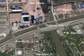
Here are a series of magnified sections of an aerial photo taken in 1953. They show the east and south sides of Sugar Land. I've annotated them to indicate various landmarks and locations. I've also provided contemporary Google aerials to help orient you.
This first zoom shows the center of town.
 |
| 1953 |
 |
| Today |
The next shows Belknap down to Terry St. on the southern edge.
 |
| 1953 |
 |
| Today |
This zoom shows Venice & Brooks Streets extending beyond Terry.
 |
| 1953 |
 |
| Today |
Here you see Alkire Lake and the future locations of Venetian Estates and Sugar Creek Commercial Center.
 |
| 1953 |
 |
| Today |
Next you see the area bounded by Venetian Estates and Alkire Lake on the north and Highway 6 on the south.
 |
| 1953 |
 |
| Today |
The next photo shows the area just south of the previous one. You see the dehydration plant, where Sugarland Industries dried alfalfa and hay after it was harvested, and the Houston Lighting & Power substation. As you can see, Highway 59 passes through that area today.
 |
| 1953 |
 |
| Today |
This photo moves eastward along Oyster Creek and shows the rail line to Galveston and San Ysidro Cemetery.
 |
| 1953 |
 |
| Today |
This final zoom moves a little further east along Oyster Creek toward Dulles Avenue and River Bend Country Club. The Stafford Cemetery is the probably location of the Stafford Plantation that Santa Anna's army burned before the Battle of San Jacinto.
 |
| 1953 |
 |
| Today |


No comments:
Post a Comment