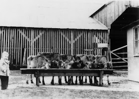
This installment of 'Images of Old Sugar Land' focuses on the dairy located in Sugar Land's west end. The dairy itself (barns, sheds, bottling plant) was located behind today's Nalco complex, just off Ulrich St.
If you're familiar with the new Imperial development, the dairy was located approximately where the new bridge across Oyster Creek is sited. The first aerial photo below will help orient you. The second aerial photo was taken around 1923 and provides another view. The land where Constellation Park and the new Imperial development is in progress served as pasture land for the dairy cows. (See the lower right of the 1923 photo.)


Here are photos of the dairy itself. Those of you with sharp eyes may notice a 'variation' in the photos. I think the first photo is the earliest one of the series. It's dated 1910. Note that the silo is detached from the barn. The other photos, including the 1923 aerial, show two silos attached to the ends of the barn. Maybe these are two different locations, but I think they renovated the set up between 1910 and 1923.
I don't have dates for many of the these photos. Many were probably taken in the mid 1930s. The two photos of Mr. Scarborough at the butter machine and the milk-bottling plant were probably taken in the 1920s.
Mr. Scarborough (I've forgotten his first name), managed the dairy, which included a milk bottling plant. He was Nan Miller's father. Ron Miller (SLHS '51) is the toddler who appears in the final photo.
 |
| Another ground view of the barn with silos attached. |
 |
| A view of the calf pen looking east, I think. |
 |
| Mr. Scarborough in the calf pen. |
 |
| A view of the cattle yard looking north. Mayfield Park is on the right bank of Oyster Creek. |
 |
| A view of the calf pen looking east toward the refinery. |
 |
| Mr. Scarborough at the butter or cheese packaging machine(?). |
 |
| The milk-bottling plant with delivery wagon. |
 |
| Ron Miller in the calf pen. |
I'll have a follow-up article on the dairy next week.


No comments:
Post a Comment